Woongarra geodata
Woongarra (Queensland) is a populated place; located in Australia in Australia/Brisbane (GMT+10) time zone. With population of 524 people, there are 4801 cities with bigger population in this country. Compared to other cities in Australia, 89.8% of cities are located further ↓South; 84.2% of cities are located further ←West and 72.3% of cities have higher elevation than Woongarra. Note1


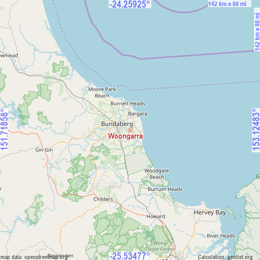
Woongarra GPS coordinates[2]
24° 53' 55.176" South, 152° 25' 18.12" East
| Map corner | latitude | longitude |
|---|---|---|
| Upper-left | -24.25925°, | 151.71858° |
| Center: | -24.89866°, | 152.4217° |
| Lower-right: | -25.53477°, | 153.12483° |
| Map W x H: | 141.8×141.8 km | = 88.1×88.1mi |
| max Lat: | -10.58257° ⇑10.2% North |
| Woongarra: | -24.89866° |
| min Lat: | ⇓89.8% South -43.31423° |
| min Long | Woongarra | max Long |
| 113.53327° | 152.4217° | 153.61246° |
| W 84.2%⇐ | ⇒15.8% E |
Elevation
Elevation of Woongarra is 21 m = 69 ft, and this is 101 m = 331 ft below average elevation for this country.
| Max E: |
1715 m = 5627 ft | 72.3% |
| Avg. | 122 m = 400 ft | |
| Woongarra | 21 m = 69 ft | |
Min E: |
-2 m = -7 ft | 27.7% |
See also: Australia elevation on elevation.city.
Geographical zone
Woongarra is located in South temperate zone (between Tropic of Capricorn and the Antarctic Circle). Distance of this Southern Tropic circle is 162.6 km =101 mi to North.| Distance of | km | miles | from Woongarra |
|---|---|---|---|
| Equator | 2768.5 | 1720.3 | to North |
| Tropic Capricorn | 162.6 | 101 | to North |
| Antarctic Circle | 4632.7 | 2878.6 | to South |
| South Pole | 7238.6 | 4497.9 | to South |


Nearby cities:
15 places around Woongarra: (largest is in red/bold)
• Ashfield
3.9 km =2.4 mi,  317°
317°
• Avenell Heights
5.5 km =3.4 mi,  280°
280°
• Bundaberg
8.3 km =5.2 mi,  295°
295°
• Bundaberg East
6.1 km =3.8 mi, 316°
• Bundaberg South
6.9 km =4.3 mi,  294°
294°
• Bundaberg West
9.1 km =5.7 mi, 288°
• Coral Cove
6.4 km =4 mi,  74°
74°
• Elliott Heads
7.1 km =4.4 mi,  105°
105°
• Innes Park
6.8 km =4.2 mi,  60°
60°
• Kalkie
7.1 km =4.4 mi,  328°
328°
• Kepnock
5.3 km =3.3 mi, 298°
• Norville
8.2 km =5.1 mi,  274°
274°
• Qunaba
7.2 km =4.5 mi,  359°
359°
• Thabeban
7.2 km =4.5 mi, 268°
• Walkervale
6.6 km =4.1 mi, 285°
Sources, notices
• [Note1] Compared only with cities in Australia existing in our database
• [Src1] Map data: © OpenStreetMap contributors (CC-BY-SA)
• [Src2] Other city data from geonames.org with taken over terms of usage.
• [Src3] Geographical zone / Annual Mean Temperature by Robert A. Rohde @ Wikipedia
