Coral Cove geodata
Coral Cove (Queensland) is a section of populated place; located in Australia in Australia/Brisbane (GMT+10) time zone. With population of 1,291 people, there are 3482 cities with bigger population in this country. Compared to other cities in Australia, 89.9% of cities are located further ↓South; 84.5% of cities are located further ←West and 85% of cities have higher elevation than Coral Cove. Note1


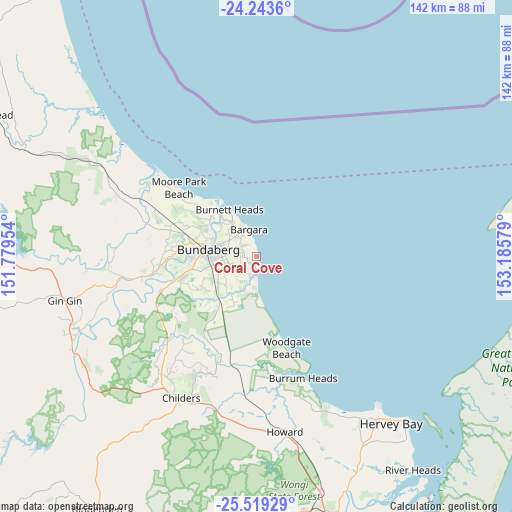
Coral Cove GPS coordinates[2]
24° 52' 59.124" South, 152° 28' 57.576" East
| Map corner | latitude | longitude |
|---|---|---|
| Upper-left | -24.2436°, | 151.77954° |
| Center: | -24.88309°, | 152.48266° |
| Lower-right: | -25.51929°, | 153.18579° |
| Map W x H: | 141.8×141.8 km | = 88.1×88.1mi |
| max Lat: | -10.58257° ⇑10.1% North |
| Coral Cove: | -24.88309° |
| min Lat: | ⇓89.9% South -43.31423° |
| min Long | Coral Cove | max Long |
| 113.53327° | 152.48266° | 153.61246° |
| W 84.5%⇐ | ⇒15.5% E |
Elevation
Elevation of Coral Cove is 12 m = 39 ft, and this is 110 m = 361 ft below average elevation for this country.
| Max E: |
1715 m = 5627 ft | 85% |
| Avg. | 122 m = 400 ft | |
| Coral Cove | 12 m = 39 ft | |
Min E: |
-2 m = -7 ft | 15% |
See also: Australia elevation on elevation.city.
Geographical zone
Coral Cove is located in South temperate zone (between Tropic of Capricorn and the Antarctic Circle). Distance of this Southern Tropic circle is 160.8 km =99.9 mi to North.| Distance of | km | miles | from Coral Cove |
|---|---|---|---|
| Equator | 2766.7 | 1719.1 | to North |
| Tropic Capricorn | 160.8 | 99.9 | to North |
| Antarctic Circle | 4634.4 | 2879.7 | to South |
| South Pole | 7240.3 | 4498.9 | to South |


Nearby cities:
15 places around Coral Cove: (largest is in red/bold)
• Ashfield
8.9 km =5.5 mi,  277°
277°
• Avenell Heights
11.6 km =7.2 mi,  266°
266°
• Bargara
7.9 km =4.9 mi,  345°
345°
• Bundaberg
13.7 km =8.5 mi, 277°
• Bundaberg East
10.7 km =6.6 mi, 284°
• Bundaberg South
12.4 km =7.7 mi, 275°
• Elliott Heads
3.8 km =2.4 mi,  168°
168°
• Innes Park
1.7 km =1.1 mi, 350°
• Kalkie
10.7 km =6.6 mi,  293°
293°
• Kepnock
10.9 km =6.8 mi, 274°
• Norville
14.3 km =8.9 mi, 265°
• Qunaba
8.3 km =5.2 mi,  311°
311°
• Thabeban
13.5 km =8.4 mi,  262°
262°
• Walkervale
12.5 km =7.8 mi, 270°
• Woongarra
6.4 km =4 mi,  254°
254°
Sources, notices
• [Note1] Compared only with cities in Australia existing in our database
• [Src1] Map data: © OpenStreetMap contributors (CC-BY-SA)
• [Src2] Other city data from geonames.org with taken over terms of usage.
• [Src3] Geographical zone / Annual Mean Temperature by Robert A. Rohde @ Wikipedia
