Mountain River geodata
Mountain River (Tasmania) is a populated place; located in Australia in Australia/Hobart (GMT+11) time zone. With population of 547 people, there are 4716 cities with bigger population in this country. Compared to other cities in Australia, 99.7% of cities are located further ↑North; 52.4% of cities are located further →East and 80.4% of cities have lower elevation than Mountain River. Note1


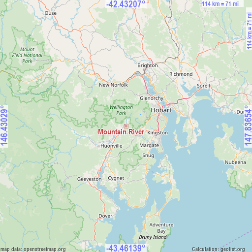
Mountain River GPS coordinates[2]
42° 56' 55.968" South, 147° 8' 0.276" East
| Map corner | latitude | longitude |
|---|---|---|
| Upper-left | -42.43207°, | 146.43029° |
| Center: | -42.94888°, | 147.13341° |
| Lower-right: | -43.46139°, | 147.83654° |
| Map W x H: | 114.4×114.4 km | = 71.1×71.1mi |
| max Lat: | -10.58257° ⇑99.7% North |
| Mountain River: | -42.94888° |
| min Lat: | ⇓0.3% South -43.31423° |
| min Long | Mountain River | max Long |
| 113.53327° | 147.13341° | 153.61246° |
| W 47.6%⇐ | ⇒52.4% E |
Elevation
Elevation of Mountain River is 185 m = 607 ft, and this is 63 m = 207 ft above average elevation for this country.
| Max E: |
1715 m = 5627 ft | 19.6% |
| Mountain River | 185 m 607 ft | |
| Avg. | 122 m = 400 ft | |
Min E: |
-2 m = -7 ft | 80.4% |
See also: Australia elevation on elevation.city.
Geographical zone
Mountain River is located in South temperate zone (between Tropic of Capricorn and the Antarctic Circle). Distance of this Southern Tropic circle is 2169.5 km =1348.1 mi to North.| Distance of | km | miles | from Mountain River |
|---|---|---|---|
| Equator | 4775.5 | 2967.4 | to North |
| Tropic Capricorn | 2169.5 | 1348.1 | to North |
| Antarctic Circle | 2625.7 | 1631.5 | to South |
| South Pole | 5231.6 | 3250.8 | to South |


Nearby cities:
15 places around Mountain River: (largest is in red/bold)
• Blackmans Bay
16.1 km =10 mi,  111°
111°
• Collinsvale
13 km =8.1 mi,  23°
23°
• Dynnyrne
15.6 km =9.7 mi,  71°
71°
• Fern Tree
11 km =6.8 mi, 73°
• Howden
15.6 km =9.7 mi,  123°
123°
• Huonville
11.5 km =7.1 mi,  217°
217°
• Kingston
14.2 km =8.8 mi,  102°
102°
• Kingston Beach
15.5 km =9.6 mi, 102°
• Lachlan
14.5 km =9 mi,  332°
332°
• Lenah Valley
14.4 km =8.9 mi,  53°
53°
• Margate
13.7 km =8.5 mi,  129°
129°
• Mount Nelson
15.6 km =9.7 mi,  78°
78°
• Ranelagh
10.3 km =6.4 mi,  229°
229°
• South Hobart
15.5 km =9.6 mi, 67°
• Tolmans Hill
14.7 km =9.1 mi, 74°
Sources, notices
• [Note1] Compared only with cities in Australia existing in our database
• [Src1] Map data: © OpenStreetMap contributors (CC-BY-SA)
• [Src2] Other city data from geonames.org with taken over terms of usage.
• [Src3] Geographical zone / Annual Mean Temperature by Robert A. Rohde @ Wikipedia
