Ranelagh geodata
Ranelagh (Tasmania) is a populated place; located in Australia in Australia/Hobart (GMT+11) time zone. With population of 1,249 people, there are 3522 cities with bigger population in this country. Compared to other cities in Australia, 99.8% of cities are located further ↑North; 52.9% of cities are located further →East and 57.6% of cities have higher elevation than Ranelagh. Note1


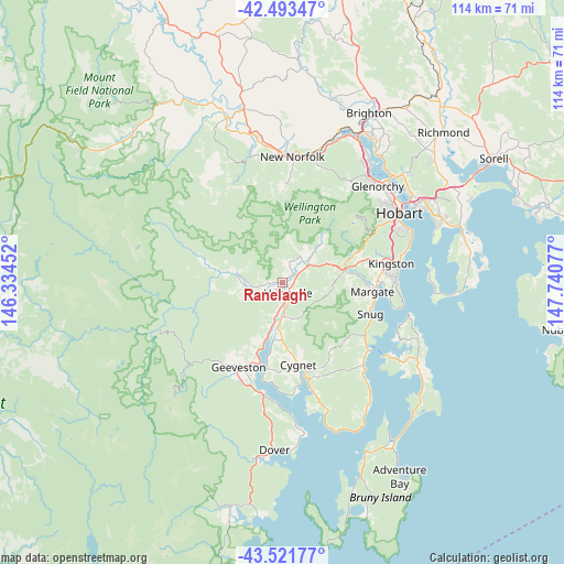
Ranelagh GPS coordinates[2]
43° 0' 35.172" South, 147° 2' 15.504" East
| Map corner | latitude | longitude |
|---|---|---|
| Upper-left | -42.49347°, | 146.33452° |
| Center: | -43.00977°, | 147.03764° |
| Lower-right: | -43.52177°, | 147.74077° |
| Map W x H: | 114.3×114.3 km | = 71×71mi |
| max Lat: | -10.58257° ⇑99.8% North |
| Ranelagh: | -43.00977° |
| min Lat: | ⇓0.2% South -43.31423° |
| min Long | Ranelagh | max Long |
| 113.53327° | 147.03764° | 153.61246° |
| W 47.1%⇐ | ⇒52.9% E |
Elevation
Elevation of Ranelagh is 35 m = 115 ft, and this is 87 m = 285 ft below average elevation for this country.
| Max E: |
1715 m = 5627 ft | 57.6% |
| Avg. | 122 m = 400 ft | |
| Ranelagh | 35 m = 115 ft | |
Min E: |
-2 m = -7 ft | 42.4% |
See also: Australia elevation on elevation.city.
Geographical zone
Ranelagh is located in South temperate zone (between Tropic of Capricorn and the Antarctic Circle). Distance of this Southern Tropic circle is 2176.3 km =1352.3 mi to North.| Distance of | km | miles | from Ranelagh |
|---|---|---|---|
| Equator | 4782.2 | 2971.5 | to North |
| Tropic Capricorn | 2176.3 | 1352.3 | to North |
| Antarctic Circle | 2618.9 | 1627.3 | to South |
| South Pole | 5224.8 | 3246.5 | to South |


Nearby cities:
15 places around Ranelagh: (largest is in red/bold)
• Blackmans Bay
22.7 km =14.1 mi,  88°
88°
• Collinsvale
22.7 km =14.1 mi,  34°
34°
• Cygnet
16.2 km =10.1 mi,  169°
169°
• Fern Tree
20.8 km =12.9 mi,  61°
61°
• Franklin
9.1 km =5.7 mi,  194°
194°
• Geeveston
19.4 km =12.1 mi,  208°
208°
• Glen Huon
6.3 km =3.9 mi,  245°
245°
• Howden
20.9 km =13 mi, 94°
• Huonville
2.5 km =1.6 mi,  160°
160°
• Kettering
21.3 km =13.2 mi,  127°
127°
• Kingston
21.9 km =13.6 mi,  80°
80°
• Lachlan
19.6 km =12.2 mi,  2°
2°
• Margate
18.4 km =11.4 mi,  96°
96°
• Mountain River
10.3 km =6.4 mi,  49°
49°
• Snug
18.7 km =11.6 mi,  109°
109°
Sources, notices
• [Note1] Compared only with cities in Australia existing in our database
• [Src1] Map data: © OpenStreetMap contributors (CC-BY-SA)
• [Src2] Other city data from geonames.org with taken over terms of usage.
• [Src3] Geographical zone / Annual Mean Temperature by Robert A. Rohde @ Wikipedia
