Gyuzdek geodata
Gyuzdek (Abşeron) is a populated place; located in Azerbaijan in Asia/Baku (GMT+4) time zone. With population of 2,462 people, there are 136 cities with bigger population in this country. Compared to other cities in Azerbaijan, 56.2% of cities are located further ↑North; 82.7% of cities are located further ←West and 51.4% of cities have higher elevation than Gyuzdek. Note1


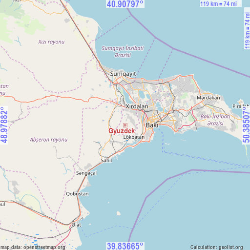
Gyuzdek GPS coordinates[2]
40° 22' 27.984" North, 49° 40' 54.984" East
| Map corner | latitude | longitude |
|---|---|---|
| Upper-left | 40.90797°, | 48.97882° |
| Center: | 40.37444°, | 49.68194° |
| Lower-right: | 39.83665°, | 50.38507° |
| Map W x H: | 119.1×119.1 km | = 74×74mi |
| max Lat: | 41.75259° ⇑56.2% North |
| Gyuzdek: | 40.37444° |
| min Lat: | ⇓43.8% South 38.45598° |
| min Long | Gyuzdek | max Long |
| 44.84846° | 49.68194° | 50.84003° |
| W 82.7%⇐ | ⇒17.3% E |
Elevation
Elevation of Gyuzdek is 156 m = 512 ft, and this is 227 m = 745 ft below average elevation for this country.
| Max E: |
2211 m = 7254 ft | 51.4% |
| Avg. | 383 m = 1257 ft | |
| Gyuzdek | 156 m = 512 ft | |
Min E: |
-26 m = -85 ft | 48.6% |
See also: Azerbaijan elevation on elevation.city.
Geographical zone
Gyuzdek is located in North temperate zone (between Tropic of Cancer and the Arctic Circle). Distance of this Northern Tropic circle is 1883.3 km =1170.2 mi to South.| Distance of | km | miles | from Gyuzdek |
|---|---|---|---|
| North Pole | 5517.8 | 3428.6 | to North |
| Arctic Circle | 2912 | 1809.4 | to North |
| Tropic Cancer | 1883.3 | 1170.2 | to South |
| Equator | 4489.2 | 2789.5 | to South |


Nearby cities:
15 places around Gyuzdek: (largest is in red/bold)
• Badamdar
11.1 km =6.9 mi,  110°
110°
• Baku
17.8 km =11.1 mi,  88°
88°
• Bilajari
13 km =8.1 mi,  53°
53°
• Binagadi
16 km =9.9 mi, 50°
• Ceyranbatan
18.7 km =11.6 mi,  354°
354°
• Corat
22 km =13.7 mi,  5°
5°
• Digah
20.9 km =13 mi, 51°
• Khirdalan
10.3 km =6.4 mi,  37°
37°
• Khodzhi-Gasan
8.5 km =5.3 mi,  59°
59°
• Korgöz
9.2 km =5.7 mi,  212°
212°
• Lökbatan
7 km =4.3 mi,  141°
141°
• Puta
8.8 km =5.5 mi,  191°
191°
• Qobu
4.3 km =2.7 mi, 38°
• Saray
17.9 km =11.1 mi, 9°
• Şonqar
9.2 km =5.7 mi,  230°
230°
Sources, notices
• [Note1] Compared only with cities in Azerbaijan existing in our database
• [Src1] Map data: © OpenStreetMap contributors (CC-BY-SA)
• [Src2] Other city data from geonames.org with taken over terms of usage.
• [Src3] Geographical zone / Annual Mean Temperature by Robert A. Rohde @ Wikipedia
