Saray geodata
Saray (Abşeron) is a populated place; located in Azerbaijan in Asia/Baku (GMT+4) time zone. With population of 10,173 people, there are 70 cities with bigger population in this country. Compared to other cities in Azerbaijan, 61.1% of cities are located further ↓South; 84.3% of cities are located further ←West and 63.2% of cities have higher elevation than Saray. Note1


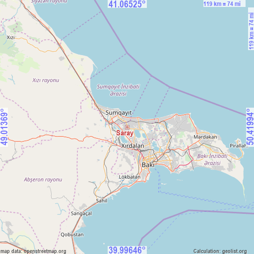
Saray GPS coordinates[2]
40° 31' 58.764" North, 49° 43' 0.516" East
| Map corner | latitude | longitude |
|---|---|---|
| Upper-left | 41.06525°, | 49.01369° |
| Center: | 40.53299°, | 49.71681° |
| Lower-right: | 39.99646°, | 50.41994° |
| Map W x H: | 118.8×118.8 km | = 73.8×73.8mi |
| max Lat: | 41.75259° ⇑38.9% North |
| Saray: | 40.53299° |
| min Lat: | ⇓61.1% South 38.45598° |
| min Long | Saray | max Long |
| 44.84846° | 49.71681° | 50.84003° |
| W 84.3%⇐ | ⇒15.7% E |
Elevation
Elevation of Saray is 42 m = 138 ft, and this is 341 m = 1119 ft below average elevation for this country.
| Max E: |
2211 m = 7254 ft | 63.2% |
| Avg. | 383 m = 1257 ft | |
| Saray | 42 m = 138 ft | |
Min E: |
-26 m = -85 ft | 36.8% |
See also: Azerbaijan elevation on elevation.city.
Geographical zone
Saray is located in North temperate zone (between Tropic of Cancer and the Arctic Circle). Distance of this Northern Tropic circle is 1900.9 km =1181.2 mi to South.| Distance of | km | miles | from Saray |
|---|---|---|---|
| North Pole | 5500.2 | 3417.7 | to North |
| Arctic Circle | 2894.3 | 1798.4 | to North |
| Tropic Cancer | 1900.9 | 1181.2 | to South |
| Equator | 4506.8 | 2800.4 | to South |


Nearby cities:
15 places around Saray: (largest is in red/bold)
• Badamdar
22.7 km =14.1 mi,  160°
160°
• Balakhani
18.8 km =11.7 mi,  114°
114°
• Bilajari
12.4 km =7.7 mi,  142°
142°
• Binagadi
12 km =7.5 mi,  128°
128°
• Ceyranbatan
4.8 km =3 mi,  281°
281°
• Corat
4.4 km =2.7 mi,  347°
347°
• Digah
14.1 km =8.8 mi, 108°
• Gyuzdek
17.9 km =11.1 mi,  189°
189°
• Hacı Zeynalabdin
16.7 km =10.4 mi,  306°
306°
• Khirdalan
10 km =6.2 mi, 161°
• Khodzhi-Gasan
14.1 km =8.8 mi, 161°
• Qobu
14.3 km =8.9 mi,  181°
181°
• Sabunçu
22 km =13.7 mi,  117°
117°
• Sumqayıt
7.5 km =4.7 mi,  327°
327°
• Zabrat
20 km =12.4 mi, 107°
Sources, notices
• [Note1] Compared only with cities in Azerbaijan existing in our database
• [Src1] Map data: © OpenStreetMap contributors (CC-BY-SA)
• [Src2] Other city data from geonames.org with taken over terms of usage.
• [Src3] Geographical zone / Annual Mean Temperature by Robert A. Rohde @ Wikipedia
