Digah geodata
Digah (Abşeron) is a populated place; located in Azerbaijan in Asia/Baku (GMT+4) time zone. With population of 3,211 people, there are 123 cities with bigger population in this country. Compared to other cities in Azerbaijan, 56.2% of cities are located further ↓South; 88.1% of cities are located further ←West and 64.3% of cities have higher elevation than Digah. Note1


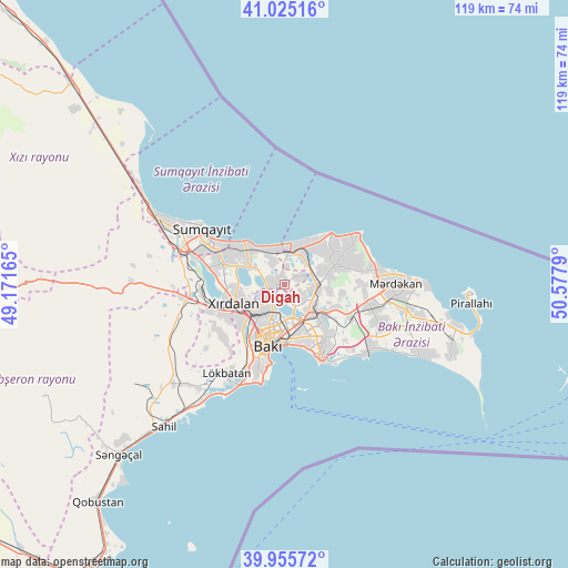
Digah GPS coordinates[2]
40° 29' 33.252" North, 49° 52' 29.172" East
| Map corner | latitude | longitude |
|---|---|---|
| Upper-left | 41.02516°, | 49.17165° |
| Center: | 40.49257°, | 49.87477° |
| Lower-right: | 39.95572°, | 50.5779° |
| Map W x H: | 118.9×118.9 km | = 73.9×73.9mi |
| max Lat: | 41.75259° ⇑43.8% North |
| Digah: | 40.49257° |
| min Lat: | ⇓56.2% South 38.45598° |
| min Long | Digah | max Long |
| 44.84846° | 49.87477° | 50.84003° |
| W 88.1%⇐ | ⇒11.9% E |
Elevation
Elevation of Digah is 39 m = 128 ft, and this is 344 m = 1129 ft below average elevation for this country.
| Max E: |
2211 m = 7254 ft | 64.3% |
| Avg. | 383 m = 1257 ft | |
| Digah | 39 m = 128 ft | |
Min E: |
-26 m = -85 ft | 35.7% |
See also: Azerbaijan elevation on elevation.city.
Geographical zone
Digah is located in North temperate zone (between Tropic of Cancer and the Arctic Circle). Distance of this Northern Tropic circle is 1896.4 km =1178.4 mi to South.| Distance of | km | miles | from Digah |
|---|---|---|---|
| North Pole | 5504.7 | 3420.5 | to North |
| Arctic Circle | 2898.8 | 1801.2 | to North |
| Tropic Cancer | 1896.4 | 1178.4 | to South |
| Equator | 4502.4 | 2797.7 | to South |


Nearby cities:
15 places around Digah: (largest is in red/bold)
• Amirdzhan
11.8 km =7.3 mi,  128°
128°
• Baku
12.9 km =8 mi,  173°
173°
• Bakıxanov
11.3 km =7 mi,  136°
136°
• Balakhani
4.9 km =3 mi, 130°
• Bilajari
7.9 km =4.9 mi,  227°
227°
• Binagadi
4.9 km =3 mi, 233°
• Khirdalan
11.3 km =7 mi,  243°
243°
• Khodzhi-Gasan
12.6 km =7.8 mi, 225°
• Maştağa
11.9 km =7.4 mi,  69°
69°
• Nardaran
13.1 km =8.1 mi,  57°
57°
• Qaraçuxur
13.6 km =8.5 mi, 141°
• Ramana
10.6 km =6.6 mi,  122°
122°
• Sabunçu
8.3 km =5.2 mi, 131°
• Saray
14.1 km =8.8 mi,  288°
288°
• Zabrat
5.9 km =3.7 mi,  106°
106°
Sources, notices
• [Note1] Compared only with cities in Azerbaijan existing in our database
• [Src1] Map data: © OpenStreetMap contributors (CC-BY-SA)
• [Src2] Other city data from geonames.org with taken over terms of usage.
• [Src3] Geographical zone / Annual Mean Temperature by Robert A. Rohde @ Wikipedia
