Vareš geodata
Vareš (Federation of B&H) is a seat of a third-order administrative division; located in Bosnia and Herzegovina in Europe/Sarajevo (GMT+2) time zone. With population of 7,193 people, there are 67 cities with bigger population in this country. Compared to other cities in Bosnia and Herzegovina, 64.9% of cities are located further ↑North; 66.4% of cities are located further ←West and 94% of cities have lower elevation than Vareš. Note1


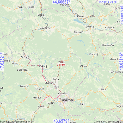
Vareš GPS coordinates[2]
44° 9' 51.984" North, 18° 19' 41.988" East
| Map corner | latitude | longitude |
|---|---|---|
| Upper-left | 44.66667°, | 17.62521° |
| Center: | 44.16444°, | 18.32833° |
| Lower-right: | 43.6579°, | 19.03146° |
| Map W x H: | 112.2×112.2 km | = 69.7×69.7mi |
| max Lat: | 45.21956° ⇑64.9% North |
| Vareš: | 44.16444° |
| min Lat: | ⇓35.1% South 42.71197° |
| min Long | Vareš | max Long |
| 15.77806° | 18.32833° | 19.36719° |
| W 66.4%⇐ | ⇒33.6% E |
Elevation
Elevation of Vareš is 845 m = 2772 ft, and this is 485.5 m = 1593 ft above average elevation for this country.
| Max E: |
1175 m = 3855 ft | 6% |
| Vareš | 845 m 2772 ft | |
| Avg. | 359.5 m = 1179 ft | |
Min E: |
17 m = 56 ft | 94% |
See also: Bosnia and Herzegovina elevation on elevation.city.
Geographical zone
Vareš is located in North temperate zone (between Tropic of Cancer and the Arctic Circle). Distance of this Northern Tropic circle is 2304.7 km =1432.1 mi to South.| Distance of | km | miles | from Vareš |
|---|---|---|---|
| North Pole | 5096.4 | 3166.8 | to North |
| Arctic Circle | 2490.5 | 1547.5 | to North |
| Tropic Cancer | 2304.7 | 1432.1 | to South |
| Equator | 4910.6 | 3051.3 | to South |


Nearby cities:
15 places around Vareš: (largest is in red/bold)
• Breza
17.1 km =10.6 mi,  198°
198°
• Careva Ćuprija
13.9 km =8.6 mi,  35°
35°
• Dobrinje
21 km =13 mi,  232°
232°
• Gornja Breza
15.6 km =9.7 mi,  205°
205°
• Gornje Moštre
21.3 km =13.2 mi,  220°
220°
• Gostovići
30.2 km =18.8 mi,  335°
335°
• Hotonj
30.4 km =18.9 mi,  172°
172°
• Ilijaš
24.1 km =15 mi,  190°
190°
• Kakanj
16.8 km =10.4 mi,  257°
257°
• Kladanj
29.9 km =18.6 mi,  76°
76°
• Mahala
17.9 km =11.1 mi, 198°
• Olovo
20.5 km =12.7 mi,  101°
101°
• Visoko
22.9 km =14.2 mi, 211°
• Vogošća
29.2 km =18.1 mi,  177°
177°
• Vozuća
21.7 km =13.5 mi,  5°
5°
Sources, notices
• [Note1] Compared only with cities in Bosnia and Herzegovina existing in our database
• [Src1] Map data: © OpenStreetMap contributors (CC-BY-SA)
• [Src2] Other city data from geonames.org with taken over terms of usage.
• [Src3] Geographical zone / Annual Mean Temperature by Robert A. Rohde @ Wikipedia
