Kalenderovci Donji geodata
Kalenderovci Donji (Srpska) is a populated place; located in Bosnia and Herzegovina in Europe/Sarajevo (GMT+2) time zone. With population of 5,890 people, there are 91 cities with bigger population in this country. Compared to other cities in Bosnia and Herzegovina, 85.3% of cities are located further ↓South; 55.5% of cities are located further →East and 77% of cities have higher elevation than Kalenderovci Donji. Note1


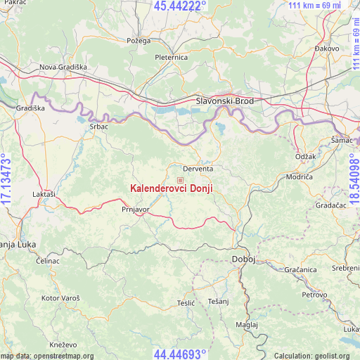
Kalenderovci Donji GPS coordinates[2]
44° 56' 48.228" North, 17° 50' 16.26" East
| Map corner | latitude | longitude |
|---|---|---|
| Upper-left | 45.44222°, | 17.13473° |
| Center: | 44.94673°, | 17.83785° |
| Lower-right: | 44.44693°, | 18.54098° |
| Map W x H: | 110.7×110.7 km | = 68.8×68.8mi |
| max Lat: | 45.21956° ⇑14.7% North |
| Kalenderovci Donji: | 44.94673° |
| min Lat: | ⇓85.3% South 42.71197° |
| min Long | Kalenderovci Do | max Long |
| 15.77806° | 17.83785° | 19.36719° |
| W 44.5%⇐ | ⇒55.5% E |
Elevation
Elevation of Kalenderovci Donji is 168 m = 551 ft, and this is 191.5 m = 628 ft below average elevation for this country.
| Max E: |
1175 m = 3855 ft | 77% |
| Avg. | 359.5 m = 1179 ft | |
| Kalenderovci Donji | 168 m = 551 ft | |
Min E: |
17 m = 56 ft | 23% |
See also: Bosnia and Herzegovina elevation on elevation.city.
Geographical zone
Kalenderovci Donji is located in North temperate zone (between Tropic of Cancer and the Arctic Circle). Distance of this Northern Tropic circle is 2391.7 km =1486.1 mi to South.| Distance of | km | miles | from Kalenderovci Donji |
|---|---|---|---|
| North Pole | 5009.5 | 3112.8 | to North |
| Arctic Circle | 2403.6 | 1493.5 | to North |
| Tropic Cancer | 2391.7 | 1486.1 | to South |
| Equator | 4997.6 | 3105.4 | to South |


Nearby cities:
15 places around Kalenderovci Donji: (largest is in red/bold)
• Brod
24.2 km =15 mi,  28°
28°
• Derventa
6.5 km =4 mi,  57°
57°
• Doboj
30.9 km =19.2 mi,  140°
140°
• Jelah
33.9 km =21.1 mi,  163°
163°
• Klokotnica
36.5 km =22.7 mi,  130°
130°
• Lukavica
33 km =20.5 mi, 127°
• Maglajani
38.4 km =23.9 mi,  270°
270°
• Matuzići
33.3 km =20.7 mi,  149°
149°
• Omanjska
29.2 km =18.1 mi, 161°
• Prnjavor
16.2 km =10.1 mi,  238°
238°
• Srbac
29.9 km =18.6 mi,  304°
304°
• Stanari
22.5 km =14 mi,  182°
182°
• Teslić
37.9 km =23.5 mi, 177°
• Tešanjka
33.4 km =20.8 mi, 155°
• Čečava
30.4 km =18.9 mi,  192°
192°
Sources, notices
• [Note1] Compared only with cities in Bosnia and Herzegovina existing in our database
• [Src1] Map data: © OpenStreetMap contributors (CC-BY-SA)
• [Src2] Other city data from geonames.org with taken over terms of usage.
• [Src3] Geographical zone / Annual Mean Temperature by Robert A. Rohde @ Wikipedia
