Brod geodata
Brod (Srpska) is a seat of a second-order administrative division; located in Bosnia and Herzegovina in Europe/Sarajevo (GMT+2) time zone. With population of 9,249 people, there are 41 cities with bigger population in this country. Compared to other cities in Bosnia and Herzegovina, 97% of cities are located further ↓South; 52.1% of cities are located further ←West and 94.3% of cities have higher elevation than Brod. Note1


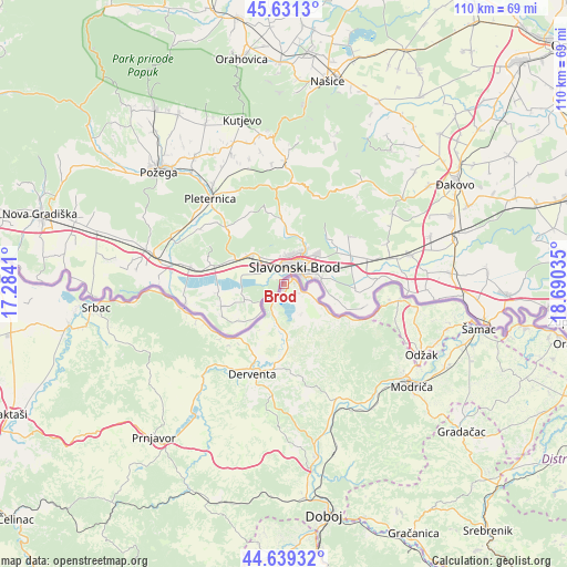
Brod GPS coordinates[2]
45° 8' 14.892" North, 17° 59' 13.992" East
| Map corner | latitude | longitude |
|---|---|---|
| Upper-left | 45.6313°, | 17.2841° |
| Center: | 45.13747°, | 17.98722° |
| Lower-right: | 44.63932°, | 18.69035° |
| Map W x H: | 110.3×110.3 km | = 68.5×68.5mi |
| max Lat: | 45.21956° ⇑3% North |
| Brod: | 45.13747° |
| min Lat: | ⇓97% South 42.71197° |
| min Long | Brod | max Long |
| 15.77806° | 17.98722° | 19.36719° |
| W 52.1%⇐ | ⇒47.9% E |
Elevation
Elevation of Brod is 85 m = 279 ft, and this is 274.5 m = 901 ft below average elevation for this country.
| Max E: |
1175 m = 3855 ft | 94.3% |
| Avg. | 359.5 m = 1179 ft | |
| Brod | 85 m = 279 ft | |
Min E: |
17 m = 56 ft | 5.7% |
See also: Bosnia and Herzegovina elevation on elevation.city.
Geographical zone
Brod is located in North temperate zone (between Tropic of Cancer and the Arctic Circle). Distance of this North polar circle is 2382.4 km =1480.4 mi to North.| Distance of | km | miles | from Brod |
|---|---|---|---|
| North Pole | 4988.2 | 3099.5 | to North |
| Arctic Circle | 2382.4 | 1480.4 | to North |
| Tropic Cancer | 2412.9 | 1499.3 | to South |
| Equator | 5018.8 | 3118.5 | to South |


Nearby cities:
15 places around Brod: (largest is in red/bold)
• Derventa
18.8 km =11.7 mi,  199°
199°
• Doboj
45.8 km =28.5 mi,  170°
170°
• Domaljevac
47.8 km =29.7 mi,  100°
100°
• Donja Dubica
33.9 km =21.1 mi, 101°
• Gradačac
45 km =28 mi,  129°
129°
• Kalenderovci Donji
24.2 km =15 mi,  208°
208°
• Klokotnica
47.7 km =29.6 mi,  160°
160°
• Lukavica
43.9 km =27.3 mi, 160°
• Mionica
48.2 km =30 mi, 128°
• Odžak
29.1 km =18.1 mi,  115°
115°
• Omanjska
48.9 km =30.4 mi,  182°
182°
• Prnjavor
39.2 km =24.4 mi,  220°
220°
• Srbac
36.7 km =22.8 mi,  263°
263°
• Stanari
45.4 km =28.2 mi, 196°
• Šamac
38.7 km =24 mi, 102°
Sources, notices
• [Note1] Compared only with cities in Bosnia and Herzegovina existing in our database
• [Src1] Map data: © OpenStreetMap contributors (CC-BY-SA)
• [Src2] Other city data from geonames.org with taken over terms of usage.
• [Src3] Geographical zone / Annual Mean Temperature by Robert A. Rohde @ Wikipedia
