Bosansko Grahovo geodata
Bosansko Grahovo (Federation of B&H) is a seat of a third-order administrative division; located in Bosnia and Herzegovina in Europe/Sarajevo (GMT+2) time zone. With population of 5,643 people, there are 101 cities with bigger population in this country. Compared to other cities in Bosnia and Herzegovina, 63.8% of cities are located further ↑North; 90.2% of cities are located further →East and 95.1% of cities have lower elevation than Bosansko Grahovo. Note1


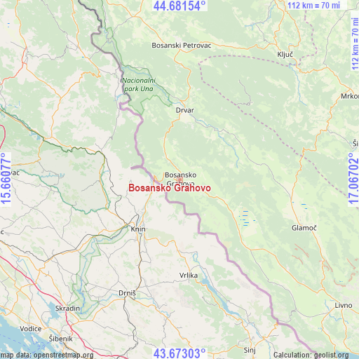
Bosansko Grahovo GPS coordinates[2]
44° 10' 45.984" North, 16° 21' 50.004" East
| Map corner | latitude | longitude |
|---|---|---|
| Upper-left | 44.68154°, | 15.66077° |
| Center: | 44.17944°, | 16.36389° |
| Lower-right: | 43.67303°, | 17.06702° |
| Map W x H: | 112.1×112.1 km | = 69.7×69.7mi |
| max Lat: | 45.21956° ⇑63.8% North |
| Bosansko Grahovo: | 44.17944° |
| min Lat: | ⇓36.2% South 42.71197° |
| min Long | Bosansko Grahov | max Long |
| 15.77806° | 16.36389° | 19.36719° |
| W 9.8%⇐ | ⇒90.2% E |
Elevation
Elevation of Bosansko Grahovo is 855 m = 2805 ft, and this is 495.5 m = 1626 ft above average elevation for this country.
| Max E: |
1175 m = 3855 ft | 4.9% |
| Bosansko Grahovo | 855 m 2805 ft | |
| Avg. | 359.5 m = 1179 ft | |
Min E: |
17 m = 56 ft | 95.1% |
See also: Bosnia and Herzegovina elevation on elevation.city.
Geographical zone
Bosansko Grahovo is located in North temperate zone (between Tropic of Cancer and the Arctic Circle). Distance of this Northern Tropic circle is 2306.4 km =1433.1 mi to South.| Distance of | km | miles | from Bosansko Grahovo |
|---|---|---|---|
| North Pole | 5094.8 | 3165.8 | to North |
| Arctic Circle | 2488.9 | 1546.5 | to North |
| Tropic Cancer | 2306.4 | 1433.1 | to South |
| Equator | 4912.3 | 3052.4 | to South |


Nearby cities:
15 places around Bosansko Grahovo: (largest is in red/bold)
• Bosanski Petrovac
41.8 km =26 mi,  0°
0°
• Drinić
37.3 km =23.2 mi,  12°
12°
• Drvar
21.7 km =13.5 mi, 3°
• Glamoč
41.4 km =25.7 mi,  111°
111°
• Gornji Ribnik
44.7 km =27.8 mi,  53°
53°
• Ključ
51.2 km =31.8 mi,  39°
39°
• Mrkonjić Grad
63 km =39.1 mi,  65°
65°
• Orašac
55.2 km =34.3 mi,  335°
335°
• Orguz
60.2 km =37.4 mi,  138°
138°
• Peći
60.3 km =37.5 mi,  33°
33°
• Podbrdo
59.5 km =37 mi,  60°
60°
• Potoci
31.3 km =19.4 mi, 40°
• Sanica
53 km =32.9 mi,  24°
24°
• Velagići
51.2 km =31.8 mi, 35°
• Šipovo
58.7 km =36.5 mi,  78°
78°
Sources, notices
• [Note1] Compared only with cities in Bosnia and Herzegovina existing in our database
• [Src1] Map data: © OpenStreetMap contributors (CC-BY-SA)
• [Src2] Other city data from geonames.org with taken over terms of usage.
• [Src3] Geographical zone / Annual Mean Temperature by Robert A. Rohde @ Wikipedia
