Zonnebeke geodata
Zonnebeke (Flanders) is a populated place; located in Belgium in Europe/Brussels (GMT+2) time zone. With population of 11,581 people, there are 260 cities with bigger population in this country. Compared to other cities in Belgium, 57% of cities are located further ↓South; 96.9% of cities are located further →East and 59.4% of cities have higher elevation than Zonnebeke. Note1
Administrative division(s):
- Level 1: Flanders
- Level 2: Provincie West-Vlaanderen
- Level 3: Arrondissement Ieper
- Level 4: Zonnebeke


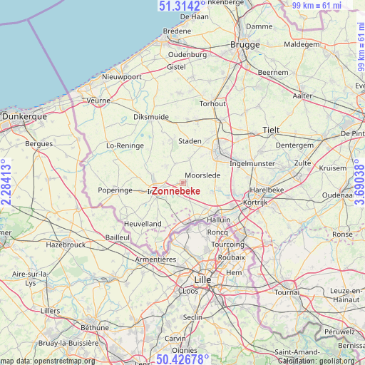
Zonnebeke GPS coordinates[2]
50° 52' 21.36" North, 2° 59' 14.1" East
| Map corner | latitude | longitude |
|---|---|---|
| Upper-left | 51.3142°, | 2.28413° |
| Center: | 50.8726°, | 2.98725° |
| Lower-right: | 50.42678°, | 3.69038° |
| Map W x H: | 98.7×98.7 km | = 61.3×61.3mi |
| max Lat: | 51.46791° ⇑43% North |
| Zonnebeke: | 50.8726° |
| min Lat: | ⇓57% South 49.53771° |
| min Long | Zonnebeke | max Long |
| 2.59368° | 2.98725° | 6.25749° |
| W 3.1%⇐ | ⇒96.9% E |
Elevation
Elevation of Zonnebeke is 34 m = 112 ft, and this is 65.5 m = 215 ft below average elevation for this country.
| Max E: |
582 m = 1909 ft | 59.4% |
| Avg. | 99.5 m = 326 ft | |
| Zonnebeke | 34 m = 112 ft | |
Min E: |
1 m = 3 ft | 40.6% |
See also: Belgium elevation on elevation.city.
Geographical zone
Zonnebeke is located in North temperate zone (between Tropic of Cancer and the Arctic Circle). Distance of this North polar circle is 1744.7 km =1084.1 mi to North.| Distance of | km | miles | from Zonnebeke |
|---|---|---|---|
| North Pole | 4350.6 | 2703.3 | to North |
| Arctic Circle | 1744.7 | 1084.1 | to North |
| Tropic Cancer | 3050.6 | 1895.6 | to South |
| Equator | 5656.5 | 3514.8 | to South |


Nearby cities:
15 places around Zonnebeke: (largest is in red/bold)
• Hooglede
14 km =8.7 mi,  28°
28°
• Houthulst
12 km =7.5 mi,  347°
347°
• Ieper
7.5 km =4.7 mi,  251°
251°
• Izegem
16.5 km =10.3 mi,  73°
73°
• Kortemark
17.9 km =11.1 mi,  12°
12°
• Ledegem
9.7 km =6 mi,  99°
99°
• Lendelede
17.6 km =10.9 mi,  85°
85°
• Menen
12.7 km =7.9 mi,  131°
131°
• Messines
13.4 km =8.3 mi,  207°
207°
• Moorslede
5.6 km =3.5 mi, 67°
• Roeselare
12.6 km =7.8 mi,  49°
49°
• Saint-Yvon
15.4 km =9.6 mi,  200°
200°
• Staden
11.5 km =7.1 mi, 9°
• Wervik
10.8 km =6.7 mi,  160°
160°
• Wevelgem
15 km =9.3 mi,  122°
122°
Sources, notices
• [Note1] Compared only with cities in Belgium existing in our database
• [Src1] Map data: © OpenStreetMap contributors (CC-BY-SA)
• [Src2] Other city data from geonames.org with taken over terms of usage.
• [Src3] Geographical zone / Annual Mean Temperature by Robert A. Rohde @ Wikipedia
