Saint-Yvon geodata
Saint-Yvon (Wallonia) is a seat of a third-order administrative division; located in Belgium in Europe/Brussels (GMT+2) time zone. In our database, there are 548 cities with bigger population. Compared to other cities in Belgium, 54.5% of cities are located further ↑North; 98% of cities are located further →East and 64.3% of cities have higher elevation than Saint-Yvon. Note1
Administrative division(s):
- Level 1: Wallonia
- Level 2: Province du Hainaut
- Level 3: Arrondissement de Mouscron
- Level 4: Comines-Warneton


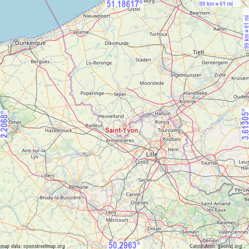
Saint-Yvon GPS coordinates[2]
50° 44' 36.06" North, 2° 54' 35.712" East
| Map corner | latitude | longitude |
|---|---|---|
| Upper-left | 51.18617°, | 2.2068° |
| Center: | 50.74335°, | 2.90992° |
| Lower-right: | 50.2963°, | 3.61305° |
| Map W x H: | 98.9×98.9 km | = 61.5×61.5mi |
| max Lat: | 51.46791° ⇑54.5% North |
| Saint-Yvon: | 50.74335° |
| min Lat: | ⇓45.5% South 49.53771° |
| min Long | Saint-Yvon | max Long |
| 2.59368° | 2.90992° | 6.25749° |
| W 2%⇐ | ⇒98% E |
Elevation
Elevation of Saint-Yvon is 27 m = 89 ft, and this is 72.5 m = 238 ft below average elevation for this country.
| Max E: |
582 m = 1909 ft | 64.3% |
| Avg. | 99.5 m = 326 ft | |
| Saint-Yvon | 27 m = 89 ft | |
Min E: |
1 m = 3 ft | 35.7% |
See also: Belgium elevation on elevation.city.
Geographical zone
Saint-Yvon is located in North temperate zone (between Tropic of Cancer and the Arctic Circle). Distance of this North polar circle is 1759 km =1093 mi to North.| Distance of | km | miles | from Saint-Yvon |
|---|---|---|---|
| North Pole | 4364.9 | 2712.2 | to North |
| Arctic Circle | 1759 | 1093 | to North |
| Tropic Cancer | 3036.2 | 1886.6 | to South |
| Equator | 5642.1 | 3505.8 | to South |


Nearby cities:
15 places around Saint-Yvon: (largest is in red/bold)
• Estaimpuis
25.6 km =15.9 mi,  99°
99°
• Houthulst
26.3 km =16.3 mi,  6°
6°
• Ieper
12.1 km =7.5 mi,  351°
351°
• Kortrijk
26.7 km =16.6 mi,  69°
69°
• Ledegem
19.7 km =12.2 mi,  49°
49°
• Menen
16.1 km =10 mi, 68°
• Messines
2.6 km =1.6 mi,  340°
340°
• Moorslede
19.6 km =12.2 mi,  32°
32°
• Mouscron
20.9 km =13 mi,  89°
89°
• Poperinge
17.8 km =11.1 mi,  313°
313°
• Roeselare
27.1 km =16.8 mi, 33°
• Staden
26.7 km =16.6 mi,  15°
15°
• Wervik
10 km =6.2 mi, 65°
• Wevelgem
19.1 km =11.9 mi, 70°
• Zonnebeke
15.4 km =9.6 mi, 20°
Sources, notices
• [Note1] Compared only with cities in Belgium existing in our database
• [Src1] Map data: © OpenStreetMap contributors (CC-BY-SA)
• [Src2] Other city data from geonames.org with taken over terms of usage.
• [Src3] Geographical zone / Annual Mean Temperature by Robert A. Rohde @ Wikipedia
