Ieper geodata
Ieper (Flanders) is a seat of a third-order administrative division; located in Belgium in Europe/Brussels (GMT+2) time zone. With population of 35,089 people, there are 38 cities with bigger population in this country. Compared to other cities in Belgium, 54.3% of cities are located further ↓South; 98.4% of cities are located further →East and 67.3% of cities have higher elevation than Ieper. Note1
Administrative division(s):
- Level 1: Flanders
- Level 2: Provincie West-Vlaanderen
- Level 3: Arrondissement Ieper
- Level 4: Ieper


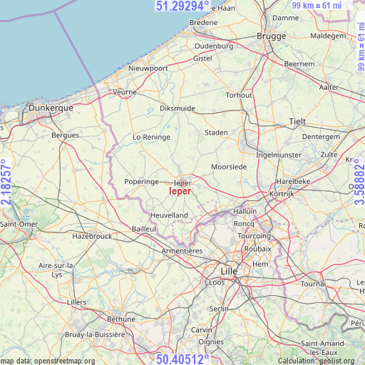
Ieper GPS coordinates[2]
50° 51' 4.104" North, 2° 53' 8.484" East
| Map corner | latitude | longitude |
|---|---|---|
| Upper-left | 51.29294°, | 2.18257° |
| Center: | 50.85114°, | 2.88569° |
| Lower-right: | 50.40512°, | 3.58882° |
| Map W x H: | 98.7×98.7 km | = 61.3×61.3mi |
| max Lat: | 51.46791° ⇑45.7% North |
| Ieper: | 50.85114° |
| min Lat: | ⇓54.3% South 49.53771° |
| min Long | Ieper | max Long |
| 2.59368° | 2.88569° | 6.25749° |
| W 1.6%⇐ | ⇒98.4% E |
Elevation
Elevation of Ieper is 24 m = 79 ft, and this is 75.5 m = 248 ft below average elevation for this country.
| Max E: |
582 m = 1909 ft | 67.3% |
| Avg. | 99.5 m = 326 ft | |
| Ieper | 24 m = 79 ft | |
Min E: |
1 m = 3 ft | 32.7% |
See also: Belgium elevation on elevation.city.
Geographical zone
Ieper is located in North temperate zone (between Tropic of Cancer and the Arctic Circle). Distance of this North polar circle is 1747.1 km =1085.6 mi to North.| Distance of | km | miles | from Ieper |
|---|---|---|---|
| North Pole | 4352.9 | 2704.8 | to North |
| Arctic Circle | 1747.1 | 1085.6 | to North |
| Tropic Cancer | 3048.2 | 1894.1 | to South |
| Equator | 5654.1 | 3513.3 | to South |


Nearby cities:
15 places around Ieper: (largest is in red/bold)
• Alveringem
21.7 km =13.5 mi,  325°
325°
• Diksmuide
20.2 km =12.6 mi,  355°
355°
• Hooglede
20.2 km =12.6 mi,  43°
43°
• Houthulst
14.8 km =9.2 mi,  17°
17°
• Ledegem
16.8 km =10.4 mi,  87°
87°
• Menen
17.7 km =11 mi,  109°
109°
• Messines
9.5 km =5.9 mi,  174°
174°
• Moorslede
13.1 km =8.1 mi,  69°
69°
• Poperinge
11.2 km =7 mi,  271°
271°
• Roeselare
19.7 km =12.2 mi,  57°
57°
• Saint-Yvon
12.1 km =7.5 mi, 171°
• Staden
16.4 km =10.2 mi,  33°
33°
• Wervik
13.3 km =8.3 mi,  126°
126°
• Wevelgem
20.5 km =12.7 mi, 106°
• Zonnebeke
7.5 km =4.7 mi, 71°
In other languages:
- In Spanish: Ypres
- In France: Ypres
- In German: Ypern
- In Italian: Ypres
- In Russian: Ипр
- In Chinese: 伊珀尔
Sources, notices
• [Note1] Compared only with cities in Belgium existing in our database
• [Src1] Map data: © OpenStreetMap contributors (CC-BY-SA)
• [Src2] Other city data from geonames.org with taken over terms of usage.
• [Src3] Geographical zone / Annual Mean Temperature by Robert A. Rohde @ Wikipedia
