Zandhoven geodata
Zandhoven (Flanders) is a populated place; located in Belgium in Europe/Brussels (GMT+2) time zone. With population of 12,306 people, there are 238 cities with bigger population in this country. Compared to other cities in Belgium, 91.9% of cities are located further ↓South; 53.6% of cities are located further ←West and 83.8% of cities have higher elevation than Zandhoven. Note1
Administrative division(s):
- Level 1: Flanders
- Level 2: Provincie Antwerpen
- Level 3: Arrondissement Antwerpen
- Level 4: Zandhoven


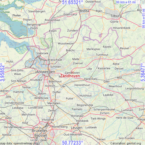
Zandhoven GPS coordinates[2]
51° 12' 53.568" North, 4° 39' 41.904" East
| Map corner | latitude | longitude |
|---|---|---|
| Upper-left | 51.65321°, | 3.95852° |
| Center: | 51.21488°, | 4.66164° |
| Lower-right: | 50.77233°, | 5.36477° |
| Map W x H: | 97.9×97.9 km | = 60.8×60.8mi |
| max Lat: | 51.46791° ⇑8.1% North |
| Zandhoven: | 51.21488° |
| min Lat: | ⇓91.9% South 49.53771° |
| min Long | Zandhoven | max Long |
| 2.59368° | 4.66164° | 6.25749° |
| W 53.6%⇐ | ⇒46.4% E |
Elevation
Elevation of Zandhoven is 11 m = 36 ft, and this is 88.5 m = 290 ft below average elevation for this country.
| Max E: |
582 m = 1909 ft | 83.8% |
| Avg. | 99.5 m = 326 ft | |
| Zandhoven | 11 m = 36 ft | |
Min E: |
1 m = 3 ft | 16.2% |
See also: Belgium elevation on elevation.city.
Geographical zone
Zandhoven is located in North temperate zone (between Tropic of Cancer and the Arctic Circle). Distance of this North polar circle is 1706.6 km =1060.4 mi to North.| Distance of | km | miles | from Zandhoven |
|---|---|---|---|
| North Pole | 4312.5 | 2679.7 | to North |
| Arctic Circle | 1706.6 | 1060.4 | to North |
| Tropic Cancer | 3088.6 | 1919.2 | to South |
| Equator | 5694.6 | 3538.5 | to South |


Nearby cities:
15 places around Zandhoven: (largest is in red/bold)
• Berlaar
10.8 km =6.7 mi,  181°
181°
• Borsbeek
12.4 km =7.7 mi,  260°
260°
• Grobbendonk
5.8 km =3.6 mi,  117°
117°
• Herenthout
10.6 km =6.6 mi,  141°
141°
• Lier
11.3 km =7 mi,  214°
214°
• Lille
11.6 km =7.2 mi,  75°
75°
• Nijlen
6 km =3.7 mi,  174°
174°
• Oostmalle
10.7 km =6.6 mi,  27°
27°
• Ranst
7.3 km =4.5 mi,  247°
247°
• Schilde
6.2 km =3.9 mi,  298°
298°
• Schoten
11.8 km =7.3 mi,  290°
290°
• Vorselaar
7.9 km =4.9 mi,  100°
100°
• Wijnegem
10 km =6.2 mi,  278°
278°
• Wommelgem
9.8 km =6.1 mi, 263°
• Zoersel
6.9 km =4.3 mi, 31°
Sources, notices
• [Note1] Compared only with cities in Belgium existing in our database
• [Src1] Map data: © OpenStreetMap contributors (CC-BY-SA)
• [Src2] Other city data from geonames.org with taken over terms of usage.
• [Src3] Geographical zone / Annual Mean Temperature by Robert A. Rohde @ Wikipedia
