Lier geodata
Lier (Flanders) is a populated place; located in Belgium in Europe/Brussels (GMT+2) time zone. With population of 33,272 people, there are 46 cities with bigger population in this country. Compared to other cities in Belgium, 83.6% of cities are located further ↓South; 50% of cities are located further ←West and 88.4% of cities have higher elevation than Lier. Note1
Administrative division(s):
- Level 1: Flanders
- Level 2: Provincie Antwerpen
- Level 3: Arrondissement Mechelen
- Level 4: Lier


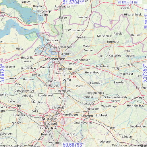
Lier GPS coordinates[2]
51° 7' 52.608" North, 4° 34' 13.476" East
| Map corner | latitude | longitude |
|---|---|---|
| Upper-left | 51.57041°, | 3.86728° |
| Center: | 51.13128°, | 4.57041° |
| Lower-right: | 50.68793°, | 5.27353° |
| Map W x H: | 98.1×98.1 km | = 61×61mi |
| max Lat: | 51.46791° ⇑16.4% North |
| Lier: | 51.13128° |
| min Lat: | ⇓83.6% South 49.53771° |
| min Long | Lier | max Long |
| 2.59368° | 4.57041° | 6.25749° |
| W 50%⇐ | ⇒50% E |
Elevation
Elevation of Lier is 9 m = 30 ft, and this is 90.5 m = 297 ft below average elevation for this country.
| Max E: |
582 m = 1909 ft | 88.4% |
| Avg. | 99.5 m = 326 ft | |
| Lier | 9 m = 30 ft | |
Min E: |
1 m = 3 ft | 11.6% |
See also: Belgium elevation on elevation.city.
Geographical zone
Lier is located in North temperate zone (between Tropic of Cancer and the Arctic Circle). Distance of this North polar circle is 1715.9 km =1066.2 mi to North.| Distance of | km | miles | from Lier |
|---|---|---|---|
| North Pole | 4321.8 | 2685.4 | to North |
| Arctic Circle | 1715.9 | 1066.2 | to North |
| Tropic Cancer | 3079.3 | 1913.4 | to South |
| Equator | 5685.3 | 3532.7 | to South |


Nearby cities:
15 places around Lier: (largest is in red/bold)
• Berlaar
6.3 km =3.9 mi,  103°
103°
• Boechout
6.3 km =3.9 mi,  299°
299°
• Borsbeek
9.4 km =5.8 mi,  320°
320°
• Duffel
5.8 km =3.6 mi,  227°
227°
• Edegem
9.2 km =5.7 mi,  287°
287°
• Hove
7.4 km =4.6 mi, 290°
• Kontich
8.6 km =5.3 mi,  270°
270°
• Lint
5.2 km =3.2 mi,  264°
264°
• Mortsel
9.2 km =5.7 mi, 295°
• Nijlen
7.7 km =4.8 mi,  64°
64°
• Putte
9.7 km =6 mi,  153°
153°
• Ranst
6.5 km =4 mi,  356°
356°
• Sint-Katelijne-Waver
7.6 km =4.7 mi,  199°
199°
• Wommelgem
8.8 km =5.5 mi,  337°
337°
• Zandhoven
11.3 km =7 mi,  34°
34°
Sources, notices
• [Note1] Compared only with cities in Belgium existing in our database
• [Src1] Map data: © OpenStreetMap contributors (CC-BY-SA)
• [Src2] Other city data from geonames.org with taken over terms of usage.
• [Src3] Geographical zone / Annual Mean Temperature by Robert A. Rohde @ Wikipedia
