Lille geodata
Lille (Flanders) is a populated place; located in Belgium in Europe/Brussels (GMT+2) time zone. With population of 15,466 people, there are 180 cities with bigger population in this country. Compared to other cities in Belgium, 94.6% of cities are located further ↓South; 59% of cities are located further ←West and 76.2% of cities have higher elevation than Lille. Note1
Administrative division(s):
- Level 1: Flanders
- Level 2: Provincie Antwerpen
- Level 3: Arrondissement Turnhout
- Level 4: Lille


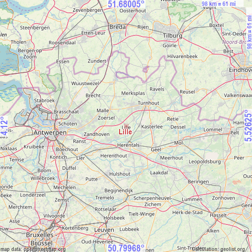
Lille GPS coordinates[2]
51° 14' 31.092" North, 4° 49' 23.268" East
| Map corner | latitude | longitude |
|---|---|---|
| Upper-left | 51.68005°, | 4.12° |
| Center: | 51.24197°, | 4.82313° |
| Lower-right: | 50.79968°, | 5.52625° |
| Map W x H: | 97.9×97.9 km | = 60.8×60.8mi |
| max Lat: | 51.46791° ⇑5.4% North |
| Lille: | 51.24197° |
| min Lat: | ⇓94.6% South 49.53771° |
| min Long | Lille | max Long |
| 2.59368° | 4.82313° | 6.25749° |
| W 59%⇐ | ⇒41% E |
Elevation
Elevation of Lille is 17 m = 56 ft, and this is 82.5 m = 271 ft below average elevation for this country.
| Max E: |
582 m = 1909 ft | 76.2% |
| Avg. | 99.5 m = 326 ft | |
| Lille | 17 m = 56 ft | |
Min E: |
1 m = 3 ft | 23.8% |
See also: Belgium elevation on elevation.city.
Geographical zone
Lille is located in North temperate zone (between Tropic of Cancer and the Arctic Circle). Distance of this North polar circle is 1703.6 km =1058.6 mi to North.| Distance of | km | miles | from Lille |
|---|---|---|---|
| North Pole | 4309.5 | 2677.8 | to North |
| Arctic Circle | 1703.6 | 1058.6 | to North |
| Tropic Cancer | 3091.7 | 1921.1 | to South |
| Equator | 5697.6 | 3540.3 | to South |


Nearby cities:
15 places around Lille: (largest is in red/bold)
• Beerse
8.8 km =5.5 mi,  13°
13°
• Grobbendonk
8.4 km =5.2 mi,  226°
226°
• Herentals
7.3 km =4.5 mi,  174°
174°
• Herenthout
12.3 km =7.6 mi,  202°
202°
• Kasterlee
10 km =6.2 mi,  90°
90°
• Merksplas
13.3 km =8.3 mi, 12°
• Nijlen
14 km =8.7 mi, 229°
• Olen
11.2 km =7 mi, 166°
• Oostmalle
9 km =5.6 mi,  315°
315°
• Rijkevorsel
12.6 km =7.8 mi,  339°
339°
• Turnhout
12.3 km =7.6 mi,  43°
43°
• Vorselaar
5.6 km =3.5 mi,  218°
218°
• Vosselaar
8.7 km =5.4 mi,  31°
31°
• Zandhoven
11.6 km =7.2 mi,  255°
255°
• Zoersel
8.2 km =5.1 mi,  290°
290°
Sources, notices
• [Note1] Compared only with cities in Belgium existing in our database
• [Src1] Map data: © OpenStreetMap contributors (CC-BY-SA)
• [Src2] Other city data from geonames.org with taken over terms of usage.
• [Src3] Geographical zone / Annual Mean Temperature by Robert A. Rohde @ Wikipedia
