Wetteren geodata
Wetteren (Flanders) is a populated place; located in Belgium in Europe/Brussels (GMT+2) time zone. With population of 22,930 people, there are 92 cities with bigger population in this country. Compared to other cities in Belgium, 71.3% of cities are located further ↓South; 77.1% of cities are located further →East and 77.4% of cities have higher elevation than Wetteren. Note1
Administrative division(s):
- Level 1: Flanders
- Level 2: Provincie Oost-Vlaanderen
- Level 3: Arrondissement Dendermonde
- Level 4: Wetteren


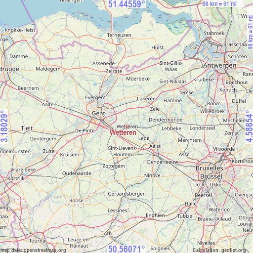
Wetteren GPS coordinates[2]
51° 0' 18.936" North, 3° 53' 0.276" East
| Map corner | latitude | longitude |
|---|---|---|
| Upper-left | 51.44559°, | 3.18029° |
| Center: | 51.00526°, | 3.88341° |
| Lower-right: | 50.56071°, | 4.58654° |
| Map W x H: | 98.4×98.4 km | = 61.1×61.1mi |
| max Lat: | 51.46791° ⇑28.7% North |
| Wetteren: | 51.00526° |
| min Lat: | ⇓71.3% South 49.53771° |
| min Long | Wetteren | max Long |
| 2.59368° | 3.88341° | 6.25749° |
| W 22.9%⇐ | ⇒77.1% E |
Elevation
Elevation of Wetteren is 16 m = 52 ft, and this is 83.5 m = 274 ft below average elevation for this country.
| Max E: |
582 m = 1909 ft | 77.4% |
| Avg. | 99.5 m = 326 ft | |
| Wetteren | 16 m = 52 ft | |
Min E: |
1 m = 3 ft | 22.6% |
See also: Belgium elevation on elevation.city.
Geographical zone
Wetteren is located in North temperate zone (between Tropic of Cancer and the Arctic Circle). Distance of this North polar circle is 1729.9 km =1074.9 mi to North.| Distance of | km | miles | from Wetteren |
|---|---|---|---|
| North Pole | 4335.8 | 2694.1 | to North |
| Arctic Circle | 1729.9 | 1074.9 | to North |
| Tropic Cancer | 3065.3 | 1904.7 | to South |
| Equator | 5671.3 | 3524 | to South |


Nearby cities:
15 places around Wetteren: (largest is in red/bold)
• Aalst
13.1 km =8.1 mi,  125°
125°
• Berlare
8.7 km =5.4 mi,  69°
69°
• Destelbergen
8.4 km =5.2 mi,  315°
315°
• Gent
12.7 km =7.9 mi,  293°
293°
• Laarne
3.6 km =2.2 mi, 321°
• Lede
8.4 km =5.2 mi,  121°
121°
• Ledeberg
10.4 km =6.5 mi, 290°
• Lochristi
10.8 km =6.7 mi,  340°
340°
• Melle
5.5 km =3.4 mi,  266°
266°
• Merelbeke
9.7 km =6 mi,  262°
262°
• Oosterzele
8.4 km =5.2 mi,  225°
225°
• Perre
13 km =8.1 mi,  186°
186°
• Sint-Lievens-Houtem
9.6 km =6 mi, 188°
• Wichelen
6.5 km =4 mi,  90°
90°
• Zele
12.9 km =8 mi,  58°
58°
Sources, notices
• [Note1] Compared only with cities in Belgium existing in our database
• [Src1] Map data: © OpenStreetMap contributors (CC-BY-SA)
• [Src2] Other city data from geonames.org with taken over terms of usage.
• [Src3] Geographical zone / Annual Mean Temperature by Robert A. Rohde @ Wikipedia
