Gent geodata
Gent (Flanders) is a populated place; located in Belgium in Europe/Brussels (GMT+2) time zone. With population of 231,493 people, there are 2 cities with bigger population in this country. Compared to other cities in Belgium, 75.6% of cities are located further ↓South; 81.9% of cities are located further →East and 86.5% of cities have higher elevation than Gent. Note1
Administrative division(s):
- Level 1: Flanders
- Level 2: Provincie Oost-Vlaanderen
- Level 3: Arrondissement Gent
- Level 4: Gent


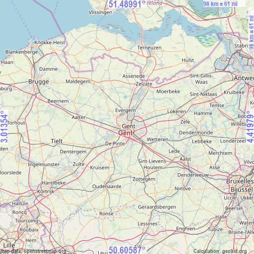
Gent GPS coordinates[2]
51° 3' 0" North, 3° 43' 0.012" East
| Map corner | latitude | longitude |
|---|---|---|
| Upper-left | 51.48991°, | 3.01354° |
| Center: | 51.05°, | 3.71667° |
| Lower-right: | 50.60587°, | 4.41979° |
| Map W x H: | 98.3×98.3 km | = 61.1×61.1mi |
| max Lat: | 51.46791° ⇑24.4% North |
| Gent: | 51.05° |
| min Lat: | ⇓75.6% South 49.53771° |
| min Long | Gent | max Long |
| 2.59368° | 3.71667° | 6.25749° |
| W 18.1%⇐ | ⇒81.9% E |
Elevation
Elevation of Gent is 10 m = 33 ft, and this is 89.5 m = 294 ft below average elevation for this country.
| Max E: |
582 m = 1909 ft | 86.5% |
| Avg. | 99.5 m = 326 ft | |
| Gent | 10 m = 33 ft | |
Min E: |
1 m = 3 ft | 13.5% |
See also: Gent elevation on elevation.city.
Geographical zone
Gent is located in North temperate zone (between Tropic of Cancer and the Arctic Circle). Distance of this North polar circle is 1724.9 km =1071.8 mi to North.| Distance of | km | miles | from Gent |
|---|---|---|---|
| North Pole | 4330.8 | 2691 | to North |
| Arctic Circle | 1724.9 | 1071.8 | to North |
| Tropic Cancer | 3070.3 | 1907.8 | to South |
| Equator | 5676.2 | 3527 | to South |


Nearby cities:
15 places around Gent: (largest is in red/bold)
• De Pinte
7.9 km =4.9 mi,  217°
217°
• Destelbergen
5.9 km =3.7 mi,  79°
79°
• Evergem
7 km =4.3 mi,  356°
356°
• Laarne
9.6 km =6 mi,  102°
102°
• Ledeberg
2.3 km =1.4 mi,  123°
123°
• Lochristi
9.6 km =6 mi,  57°
57°
• Lovendegem
9.2 km =5.7 mi,  308°
308°
• Melle
8.2 km =5.1 mi,  130°
130°
• Merelbeke
6.5 km =4 mi,  161°
161°
• Nazareth
13.4 km =8.3 mi, 219°
• Nevele
12.1 km =7.5 mi,  262°
262°
• Oosterzele
12.2 km =7.6 mi,  152°
152°
• Sint-Martens-Latem
6.8 km =4.2 mi,  234°
234°
• Wetteren
12.7 km =7.9 mi,  113°
113°
• Zomergem
13.1 km =8.1 mi, 306°
In other languages:
- In Spanish: Gante
- In France: Gand
- In Italian: Gand
- In Russian: Гент
- In Chinese: 根特
Sources, notices
• [Note1] Compared only with cities in Belgium existing in our database
• [Src1] Map data: © OpenStreetMap contributors (CC-BY-SA)
• [Src2] Other city data from geonames.org with taken over terms of usage.
• [Src3] Geographical zone / Annual Mean Temperature by Robert A. Rohde @ Wikipedia
