Sint-Lievens-Houtem geodata
Sint-Lievens-Houtem (Flanders) is a populated place; located in Belgium in Europe/Brussels (GMT+2) time zone. With population of 9,146 people, there are 328 cities with bigger population in this country. Compared to other cities in Belgium, 62.8% of cities are located further ↓South; 77.8% of cities are located further →East and 57.8% of cities have higher elevation than Sint-Lievens-Houtem. Note1
Administrative division(s):
- Level 1: Flanders
- Level 2: Provincie Oost-Vlaanderen
- Level 3: Arrondissement Aalst
- Level 4: Sint-Lievens-Houtem


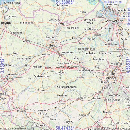
Sint-Lievens-Houtem GPS coordinates[2]
50° 55' 10.92" North, 3° 51' 44.1" East
| Map corner | latitude | longitude |
|---|---|---|
| Upper-left | 51.36085°, | 3.15912° |
| Center: | 50.9197°, | 3.86225° |
| Lower-right: | 50.47433°, | 4.56537° |
| Map W x H: | 98.6×98.6 km | = 61.3×61.3mi |
| max Lat: | 51.46791° ⇑37.2% North |
| Sint-Lievens-Houtem: | 50.9197° |
| min Lat: | ⇓62.8% South 49.53771° |
| min Long | Sint-Lievens-Ho | max Long |
| 2.59368° | 3.86225° | 6.25749° |
| W 22.2%⇐ | ⇒77.8% E |
Elevation
Elevation of Sint-Lievens-Houtem is 38 m = 125 ft, and this is 61.5 m = 202 ft below average elevation for this country.
| Max E: |
582 m = 1909 ft | 57.8% |
| Avg. | 99.5 m = 326 ft | |
| Sint-Lievens-Houtem | 38 m = 125 ft | |
Min E: |
1 m = 3 ft | 42.2% |
See also: Belgium elevation on elevation.city.
Geographical zone
Sint-Lievens-Houtem is located in North temperate zone (between Tropic of Cancer and the Arctic Circle). Distance of this North polar circle is 1739.4 km =1080.8 mi to North.| Distance of | km | miles | from Sint-Lievens-Houtem |
|---|---|---|---|
| North Pole | 4345.3 | 2700 | to North |
| Arctic Circle | 1739.4 | 1080.8 | to North |
| Tropic Cancer | 3055.8 | 1898.8 | to South |
| Equator | 5661.7 | 3518 | to South |


Nearby cities:
15 places around Sint-Lievens-Houtem: (largest is in red/bold)
• Aalst
12.3 km =7.6 mi,  81°
81°
• Gavere
14.1 km =8.8 mi,  274°
274°
• Haaltert
9.8 km =6.1 mi,  98°
98°
• Herzele
4.1 km =2.5 mi,  151°
151°
• Laarne
12.4 km =7.7 mi,  356°
356°
• Lede
10.1 km =6.3 mi,  59°
59°
• Melle
10 km =6.2 mi,  336°
336°
• Merelbeke
11.6 km =7.2 mi,  315°
315°
• Oosterzele
5.8 km =3.6 mi,  309°
309°
• Perre
3.4 km =2.1 mi,  181°
181°
• Sint-Maria-Lierde
11.3 km =7 mi,  186°
186°
• Wetteren
9.6 km =6 mi,  8°
8°
• Wichelen
12.4 km =7.7 mi,  40°
40°
• Zingem
14.8 km =9.2 mi,  263°
263°
• Zottegem
6.7 km =4.2 mi,  213°
213°
Sources, notices
• [Note1] Compared only with cities in Belgium existing in our database
• [Src1] Map data: © OpenStreetMap contributors (CC-BY-SA)
• [Src2] Other city data from geonames.org with taken over terms of usage.
• [Src3] Geographical zone / Annual Mean Temperature by Robert A. Rohde @ Wikipedia
