Zele geodata
Zele (Flanders) is a populated place; located in Belgium in Europe/Brussels (GMT+2) time zone. With population of 20,236 people, there are 118 cities with bigger population in this country. Compared to other cities in Belgium, 77.4% of cities are located further ↓South; 73.3% of cities are located further →East and 96% of cities have higher elevation than Zele. Note1
Administrative division(s):
- Level 1: Flanders
- Level 2: Provincie Oost-Vlaanderen
- Level 3: Arrondissement Dendermonde
- Level 4: Zele


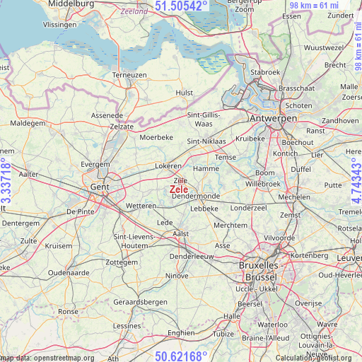
Zele GPS coordinates[2]
51° 3' 56.376" North, 4° 2' 25.08" East
| Map corner | latitude | longitude |
|---|---|---|
| Upper-left | 51.50542°, | 3.33718° |
| Center: | 51.06566°, | 4.0403° |
| Lower-right: | 50.62168°, | 4.74343° |
| Map W x H: | 98.3×98.3 km | = 61.1×61.1mi |
| max Lat: | 51.46791° ⇑22.6% North |
| Zele: | 51.06566° |
| min Lat: | ⇓77.4% South 49.53771° |
| min Long | Zele | max Long |
| 2.59368° | 4.0403° | 6.25749° |
| W 26.7%⇐ | ⇒73.3% E |
Elevation
Elevation of Zele is 6 m = 20 ft, and this is 93.5 m = 307 ft below average elevation for this country.
| Max E: |
582 m = 1909 ft | 96% |
| Avg. | 99.5 m = 326 ft | |
| Zele | 6 m = 20 ft | |
Min E: |
1 m = 3 ft | 4% |
See also: Belgium elevation on elevation.city.
Geographical zone
Zele is located in North temperate zone (between Tropic of Cancer and the Arctic Circle). Distance of this North polar circle is 1723.2 km =1070.7 mi to North.| Distance of | km | miles | from Zele |
|---|---|---|---|
| North Pole | 4329.1 | 2690 | to North |
| Arctic Circle | 1723.2 | 1070.7 | to North |
| Tropic Cancer | 3072.1 | 1908.9 | to South |
| Equator | 5678 | 3528.1 | to South |


Nearby cities:
15 places around Zele: (largest is in red/bold)
• Berlare
4.6 km =2.9 mi,  218°
218°
• Buggenhout
12.6 km =7.8 mi,  116°
116°
• Dendermonde
5.9 km =3.7 mi,  134°
134°
• Hamme
7.7 km =4.8 mi,  61°
61°
• Laarne
13.8 km =8.6 mi,  253°
253°
• Lebbeke
9.5 km =5.9 mi,  135°
135°
• Lede
11.7 km =7.3 mi,  198°
198°
• Lokeren
5.3 km =3.3 mi,  322°
322°
• Moerbeke
14.3 km =8.9 mi,  327°
327°
• Sint-Amands
11.9 km =7.4 mi,  94°
94°
• Sint-Niklaas
13.2 km =8.2 mi,  33°
33°
• Temse
13.9 km =8.6 mi, 60°
• Waasmunster
5.5 km =3.4 mi,  35°
35°
• Wetteren
12.9 km =8 mi,  238°
238°
• Wichelen
8 km =5 mi,  213°
213°
Sources, notices
• [Note1] Compared only with cities in Belgium existing in our database
• [Src1] Map data: © OpenStreetMap contributors (CC-BY-SA)
• [Src2] Other city data from geonames.org with taken over terms of usage.
• [Src3] Geographical zone / Annual Mean Temperature by Robert A. Rohde @ Wikipedia
