Stekene geodata
Stekene (Flanders) is a populated place; located in Belgium in Europe/Brussels (GMT+2) time zone. With population of 16,989 people, there are 158 cities with bigger population in this country. Compared to other cities in Belgium, 91.2% of cities are located further ↓South; 73.5% of cities are located further →East and 93.3% of cities have higher elevation than Stekene. Note1
Administrative division(s):
- Level 1: Flanders
- Level 2: Provincie Oost-Vlaanderen
- Level 3: Arrondissement Sint-Niklaas
- Level 4: Stekene


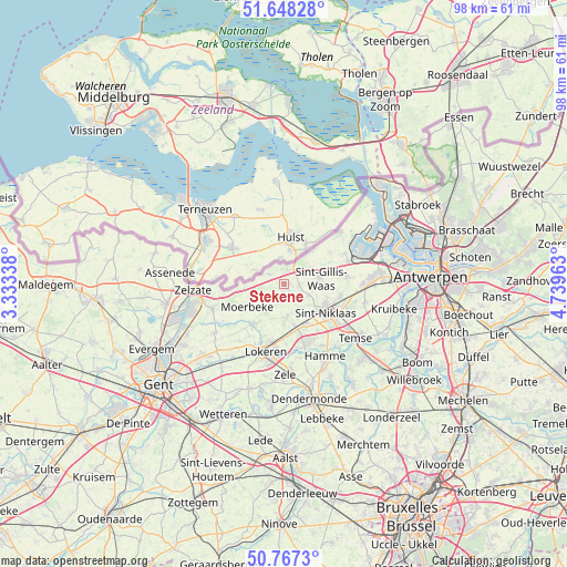
Stekene GPS coordinates[2]
51° 12' 35.64" North, 4° 2' 11.436" East
| Map corner | latitude | longitude |
|---|---|---|
| Upper-left | 51.64828°, | 3.33338° |
| Center: | 51.2099°, | 4.03651° |
| Lower-right: | 50.7673°, | 4.73963° |
| Map W x H: | 98×98 km | = 60.9×60.9mi |
| max Lat: | 51.46791° ⇑8.8% North |
| Stekene: | 51.2099° |
| min Lat: | ⇓91.2% South 49.53771° |
| min Long | Stekene | max Long |
| 2.59368° | 4.03651° | 6.25749° |
| W 26.5%⇐ | ⇒73.5% E |
Elevation
Elevation of Stekene is 7 m = 23 ft, and this is 92.5 m = 303 ft below average elevation for this country.
| Max E: |
582 m = 1909 ft | 93.3% |
| Avg. | 99.5 m = 326 ft | |
| Stekene | 7 m = 23 ft | |
Min E: |
1 m = 3 ft | 6.7% |
See also: Belgium elevation on elevation.city.
Geographical zone
Stekene is located in North temperate zone (between Tropic of Cancer and the Arctic Circle). Distance of this North polar circle is 1707.2 km =1060.8 mi to North.| Distance of | km | miles | from Stekene |
|---|---|---|---|
| North Pole | 4313.1 | 2680 | to North |
| Arctic Circle | 1707.2 | 1060.8 | to North |
| Tropic Cancer | 3088.1 | 1918.9 | to South |
| Equator | 5694 | 3538.1 | to South |


Nearby cities:
15 places around Stekene: (largest is in red/bold)
• Berlare
19.8 km =12.3 mi,  187°
187°
• Beveren
15.3 km =9.5 mi,  89°
89°
• Bornem
19.1 km =11.9 mi,  130°
130°
• Hamme
14.3 km =8.9 mi,  150°
150°
• Kruibeke
19.9 km =12.4 mi,  102°
102°
• Lochristi
19 km =11.8 mi,  228°
228°
• Lokeren
12.2 km =7.6 mi, 194°
• Moerbeke
8.4 km =5.2 mi,  241°
241°
• Sint-Gillis-Waas
6.2 km =3.9 mi,  80°
80°
• Sint-Niklaas
9 km =5.6 mi,  123°
123°
• Temse
15.4 km =9.6 mi, 126°
• Waasmunster
12.1 km =7.5 mi,  163°
163°
• Wachtebeke
12.4 km =7.7 mi,  248°
248°
• Zele
16 km =9.9 mi,  179°
179°
• Zelzate
16.1 km =10 mi,  261°
261°
Sources, notices
• [Note1] Compared only with cities in Belgium existing in our database
• [Src1] Map data: © OpenStreetMap contributors (CC-BY-SA)
• [Src2] Other city data from geonames.org with taken over terms of usage.
• [Src3] Geographical zone / Annual Mean Temperature by Robert A. Rohde @ Wikipedia
