Sombreffe geodata
Sombreffe (Wallonia) is a populated place; located in Belgium in Europe/Brussels (GMT+2) time zone. With population of 7,452 people, there are 387 cities with bigger population in this country. Compared to other cities in Belgium, 75.3% of cities are located further ↑North; 51.1% of cities are located further ←West and 74.7% of cities have lower elevation than Sombreffe. Note1
Administrative division(s):
- Level 1: Wallonia
- Level 2: Province de Namur
- Level 3: Arrondissement de Namur
- Level 4: Sombreffe


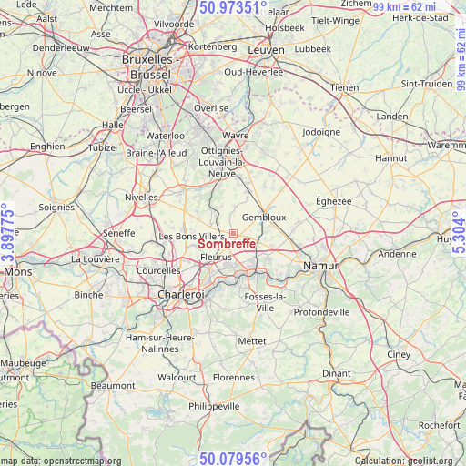
Sombreffe GPS coordinates[2]
50° 31' 43.14" North, 4° 36' 3.132" East
| Map corner | latitude | longitude |
|---|---|---|
| Upper-left | 50.97351°, | 3.89775° |
| Center: | 50.52865°, | 4.60087° |
| Lower-right: | 50.07956°, | 5.304° |
| Map W x H: | 99.4×99.4 km | = 61.8×61.8mi |
| max Lat: | 51.46791° ⇑75.3% North |
| Sombreffe: | 50.52865° |
| min Lat: | ⇓24.7% South 49.53771° |
| min Long | Sombreffe | max Long |
| 2.59368° | 4.60087° | 6.25749° |
| W 51.1%⇐ | ⇒48.9% E |
Elevation
Elevation of Sombreffe is 146 m = 479 ft, and this is 46.5 m = 153 ft above average elevation for this country.
| Max E: |
582 m = 1909 ft | 25.3% |
| Sombreffe | 146 m 479 ft | |
| Avg. | 99.5 m = 326 ft | |
Min E: |
1 m = 3 ft | 74.7% |
See also: Belgium elevation on elevation.city.
Geographical zone
Sombreffe is located in North temperate zone (between Tropic of Cancer and the Arctic Circle). Distance of this North polar circle is 1782.9 km =1107.8 mi to North.| Distance of | km | miles | from Sombreffe |
|---|---|---|---|
| North Pole | 4388.8 | 2727.1 | to North |
| Arctic Circle | 1782.9 | 1107.8 | to North |
| Tropic Cancer | 3012.3 | 1871.8 | to South |
| Equator | 5618.3 | 3491 | to South |


Nearby cities:
15 places around Sombreffe: (largest is in red/bold)
• Aiseau
13.1 km =8.1 mi,  184°
184°
• Brunehault
12.2 km =7.6 mi,  257°
257°
• Chastre
8.3 km =5.2 mi,  16°
16°
• Chastre-Villeroux-Blanmont
9.3 km =5.8 mi, 18°
• Châtelet
14.8 km =9.2 mi,  200°
200°
• Court-Saint-Étienne
11.9 km =7.4 mi,  348°
348°
• Farciennes
11.7 km =7.3 mi, 200°
• Fleurus
6.2 km =3.9 mi,  215°
215°
• Floreffe
15.4 km =9.6 mi,  132°
132°
• Gembloux
7.8 km =4.8 mi,  62°
62°
• Genappe
14 km =8.7 mi,  311°
311°
• La Bruyère
14.9 km =9.3 mi, 176°
• Mont-Saint-Guibert
11.8 km =7.3 mi,  3°
3°
• Villers-la-Ville
7.3 km =4.5 mi, 305°
• Walhain-Saint-Paul
12.9 km =8 mi,  32°
32°
Sources, notices
• [Note1] Compared only with cities in Belgium existing in our database
• [Src1] Map data: © OpenStreetMap contributors (CC-BY-SA)
• [Src2] Other city data from geonames.org with taken over terms of usage.
• [Src3] Geographical zone / Annual Mean Temperature by Robert A. Rohde @ Wikipedia
