Floreffe geodata
Floreffe (Wallonia) is a populated place; located in Belgium in Europe/Brussels (GMT+2) time zone. With population of 7,480 people, there are 386 cities with bigger population in this country. Compared to other cities in Belgium, 80.9% of cities are located further ↑North; 57.4% of cities are located further ←West and 63.5% of cities have lower elevation than Floreffe. Note1
Administrative division(s):
- Level 1: Wallonia
- Level 2: Province de Namur
- Level 3: Arrondissement de Namur
- Level 4: Floreffe


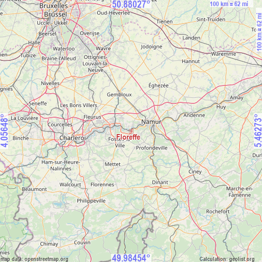
Floreffe GPS coordinates[2]
50° 26' 4.272" North, 4° 45' 34.56" East
| Map corner | latitude | longitude |
|---|---|---|
| Upper-left | 50.88027°, | 4.05648° |
| Center: | 50.43452°, | 4.7596° |
| Lower-right: | 49.98454°, | 5.46273° |
| Map W x H: | 99.6×99.6 km | = 61.9×61.9mi |
| max Lat: | 51.46791° ⇑80.9% North |
| Floreffe: | 50.43452° |
| min Lat: | ⇓19.1% South 49.53771° |
| min Long | Floreffe | max Long |
| 2.59368° | 4.7596° | 6.25749° |
| W 57.4%⇐ | ⇒42.6% E |
Elevation
Elevation of Floreffe is 92 m = 302 ft, and this is 7.5 m = 25 ft below average elevation for this country.
| Max E: |
582 m = 1909 ft | 36.5% |
| Avg. | 99.5 m = 326 ft | |
| Floreffe | 92 m = 302 ft | |
Min E: |
1 m = 3 ft | 63.5% |
See also: Belgium elevation on elevation.city.
Geographical zone
Floreffe is located in North temperate zone (between Tropic of Cancer and the Arctic Circle). Distance of this North polar circle is 1793.4 km =1114.4 mi to North.| Distance of | km | miles | from Floreffe |
|---|---|---|---|
| North Pole | 4399.3 | 2733.6 | to North |
| Arctic Circle | 1793.4 | 1114.4 | to North |
| Tropic Cancer | 3001.9 | 1865.3 | to South |
| Equator | 5607.8 | 3484.5 | to South |


Nearby cities:
15 places around Floreffe: (largest is in red/bold)
• Aiseau
12.5 km =7.8 mi,  258°
258°
• Anhée
16.2 km =10.1 mi,  148°
148°
• Châtelet
16.8 km =10.4 mi, 258°
• Farciennes
15.5 km =9.6 mi,  268°
268°
• Fleurus
15.8 km =9.8 mi,  290°
290°
• Fosses-la-Ville
6.3 km =3.9 mi,  225°
225°
• Gembloux
14.8 km =9.2 mi,  343°
343°
• Gerpinnes
19.7 km =12.2 mi,  236°
236°
• La Bruyère
11.2 km =7 mi,  246°
246°
• Marchovelette
16.2 km =10.1 mi,  52°
52°
• Mettet
14.4 km =8.9 mi,  208°
208°
• Namur
8.4 km =5.2 mi,  64°
64°
• Profondeville
9.9 km =6.2 mi,  131°
131°
• Sombreffe
15.4 km =9.6 mi,  312°
312°
• Yvoir
14.6 km =9.1 mi,  144°
144°
Sources, notices
• [Note1] Compared only with cities in Belgium existing in our database
• [Src1] Map data: © OpenStreetMap contributors (CC-BY-SA)
• [Src2] Other city data from geonames.org with taken over terms of usage.
• [Src3] Geographical zone / Annual Mean Temperature by Robert A. Rohde @ Wikipedia
