Chastre geodata
Chastre (Wallonia) is a seat of a fourth-order administrative division; located in Belgium in Europe/Brussels (GMT+2) time zone. In our database, there are 548 cities with bigger population. Compared to other cities in Belgium, 69% of cities are located further ↑North; 52.5% of cities are located further ←West and 73.1% of cities have lower elevation than Chastre. Note1
Administrative division(s):
- Level 1: Wallonia
- Level 2: Province du Brabant Wallon
- Level 3: Arrondissement de Nivelles
- Level 4: Chastre


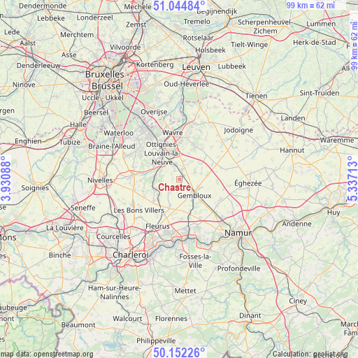
Chastre GPS coordinates[2]
50° 36' 2.412" North, 4° 38' 2.4" East
| Map corner | latitude | longitude |
|---|---|---|
| Upper-left | 51.04484°, | 3.93088° |
| Center: | 50.60067°, | 4.634° |
| Lower-right: | 50.15226°, | 5.33713° |
| Map W x H: | 99.2×99.2 km | = 61.6×61.6mi |
| max Lat: | 51.46791° ⇑69% North |
| Chastre: | 50.60067° |
| min Lat: | ⇓31% South 49.53771° |
| min Long | Chastre | max Long |
| 2.59368° | 4.634° | 6.25749° |
| W 52.5%⇐ | ⇒47.5% E |
Elevation
Elevation of Chastre is 135 m = 443 ft, and this is 35.5 m = 116 ft above average elevation for this country.
| Max E: |
582 m = 1909 ft | 26.9% |
| Chastre | 135 m 443 ft | |
| Avg. | 99.5 m = 326 ft | |
Min E: |
1 m = 3 ft | 73.1% |
See also: Belgium elevation on elevation.city.
Geographical zone
Chastre is located in North temperate zone (between Tropic of Cancer and the Arctic Circle). Distance of this North polar circle is 1774.9 km =1102.9 mi to North.| Distance of | km | miles | from Chastre |
|---|---|---|---|
| North Pole | 4380.8 | 2722.1 | to North |
| Arctic Circle | 1774.9 | 1102.9 | to North |
| Tropic Cancer | 3020.3 | 1876.7 | to South |
| Equator | 5626.3 | 3496 | to South |


Nearby cities:
15 places around Chastre: (largest is in red/bold)
• Basse Lasne
14.5 km =9 mi,  316°
316°
• Chastre-Villeroux-Blanmont
1 km =0.6 mi,  32°
32°
• Chaumont-Gistoux
10.5 km =6.5 mi,  35°
35°
• Court-Saint-Étienne
5.9 km =3.7 mi,  308°
308°
• Fleurus
14.3 km =8.9 mi,  204°
204°
• Gembloux
6.3 km =3.9 mi,  133°
133°
• Genappe
12.9 km =8 mi,  275°
275°
• Louvain-la-Neuve
7.6 km =4.7 mi,  349°
349°
• Mont-Saint-Guibert
4.1 km =2.5 mi,  336°
336°
• Ottignies
8.6 km =5.3 mi,  326°
326°
• Perwez
12.9 km =8 mi,  78°
78°
• Sombreffe
8.3 km =5.2 mi, 196°
• Villers-la-Ville
9.1 km =5.7 mi,  245°
245°
• Walhain-Saint-Paul
5.4 km =3.4 mi,  57°
57°
• Wavre
13.2 km =8.2 mi, 349°
Sources, notices
• [Note1] Compared only with cities in Belgium existing in our database
• [Src1] Map data: © OpenStreetMap contributors (CC-BY-SA)
• [Src2] Other city data from geonames.org with taken over terms of usage.
• [Src3] Geographical zone / Annual Mean Temperature by Robert A. Rohde @ Wikipedia
