Pittem geodata
Pittem (Flanders) is a populated place; located in Belgium in Europe/Brussels (GMT+2) time zone. With population of 6,589 people, there are 406 cities with bigger population in this country. Compared to other cities in Belgium, 69.9% of cities are located further ↓South; 91.7% of cities are located further →East and 60.6% of cities have higher elevation than Pittem. Note1
Administrative division(s):
- Level 1: Flanders
- Level 2: Provincie West-Vlaanderen
- Level 3: Arrondissement Tielt
- Level 4: Pittem


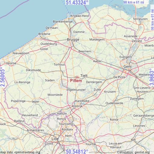
Pittem GPS coordinates[2]
50° 59' 34.044" North, 3° 15' 47.412" East
| Map corner | latitude | longitude |
|---|---|---|
| Upper-left | 51.43324°, | 2.56005° |
| Center: | 50.99279°, | 3.26317° |
| Lower-right: | 50.54812°, | 3.9663° |
| Map W x H: | 98.4×98.4 km | = 61.1×61.1mi |
| max Lat: | 51.46791° ⇑30.1% North |
| Pittem: | 50.99279° |
| min Lat: | ⇓69.9% South 49.53771° |
| min Long | Pittem | max Long |
| 2.59368° | 3.26317° | 6.25749° |
| W 8.3%⇐ | ⇒91.7% E |
Elevation
Elevation of Pittem is 32 m = 105 ft, and this is 67.5 m = 221 ft below average elevation for this country.
| Max E: |
582 m = 1909 ft | 60.6% |
| Avg. | 99.5 m = 326 ft | |
| Pittem | 32 m = 105 ft | |
Min E: |
1 m = 3 ft | 39.4% |
See also: Belgium elevation on elevation.city.
Geographical zone
Pittem is located in North temperate zone (between Tropic of Cancer and the Arctic Circle). Distance of this North polar circle is 1731.3 km =1075.8 mi to North.| Distance of | km | miles | from Pittem |
|---|---|---|---|
| North Pole | 4337.2 | 2695 | to North |
| Arctic Circle | 1731.3 | 1075.8 | to North |
| Tropic Cancer | 3063.9 | 1903.8 | to South |
| Equator | 5669.9 | 3523.1 | to South |


Nearby cities:
15 places around Pittem: (largest is in red/bold)
• Ardooie
5 km =3.1 mi,  247°
247°
• Dentergem
11.2 km =7 mi,  106°
106°
• Hooglede
12.6 km =7.8 mi,  265°
265°
• Ingelmunster
8 km =5 mi,  183°
183°
• Izegem
9.4 km =5.8 mi,  201°
201°
• Lendelede
12 km =7.5 mi,  188°
188°
• Lichtervelde
9.1 km =5.7 mi,  299°
299°
• Meulebeke
4.9 km =3 mi,  159°
159°
• Oostrozebeke
9.6 km =6 mi,  146°
146°
• Roeselare
11.1 km =6.9 mi,  242°
242°
• Ruiselede
10.6 km =6.6 mi,  59°
59°
• Tielt
4.5 km =2.8 mi,  80°
80°
• Torhout
13.9 km =8.6 mi,  305°
305°
• Wielsbeke
12.6 km =7.8 mi,  144°
144°
• Wingene
7.3 km =4.5 mi,  5°
5°
Sources, notices
• [Note1] Compared only with cities in Belgium existing in our database
• [Src1] Map data: © OpenStreetMap contributors (CC-BY-SA)
• [Src2] Other city data from geonames.org with taken over terms of usage.
• [Src3] Geographical zone / Annual Mean Temperature by Robert A. Rohde @ Wikipedia
