Wingene geodata
Wingene (Flanders) is a populated place; located in Belgium in Europe/Brussels (GMT+2) time zone. With population of 12,887 people, there are 229 cities with bigger population in this country. Compared to other cities in Belgium, 76.5% of cities are located further ↓South; 91% of cities are located further →East and 64.6% of cities have higher elevation than Wingene. Note1
Administrative division(s):
- Level 1: Flanders
- Level 2: Provincie West-Vlaanderen
- Level 3: Arrondissement Tielt
- Level 4: Wingene


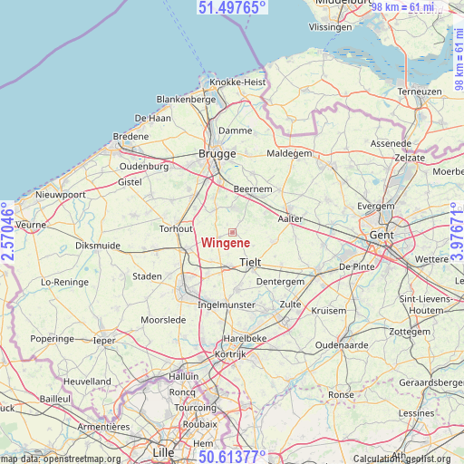
Wingene GPS coordinates[2]
51° 3' 28.152" North, 3° 16' 24.924" East
| Map corner | latitude | longitude |
|---|---|---|
| Upper-left | 51.49765°, | 2.57046° |
| Center: | 51.05782°, | 3.27359° |
| Lower-right: | 50.61377°, | 3.97671° |
| Map W x H: | 98.3×98.3 km | = 61.1×61.1mi |
| max Lat: | 51.46791° ⇑23.5% North |
| Wingene: | 51.05782° |
| min Lat: | ⇓76.5% South 49.53771° |
| min Long | Wingene | max Long |
| 2.59368° | 3.27359° | 6.25749° |
| W 9%⇐ | ⇒91% E |
Elevation
Elevation of Wingene is 26 m = 85 ft, and this is 73.5 m = 241 ft below average elevation for this country.
| Max E: |
582 m = 1909 ft | 64.6% |
| Avg. | 99.5 m = 326 ft | |
| Wingene | 26 m = 85 ft | |
Min E: |
1 m = 3 ft | 35.4% |
See also: Belgium elevation on elevation.city.
Geographical zone
Wingene is located in North temperate zone (between Tropic of Cancer and the Arctic Circle). Distance of this North polar circle is 1724.1 km =1071.3 mi to North.| Distance of | km | miles | from Wingene |
|---|---|---|---|
| North Pole | 4330 | 2690.5 | to North |
| Arctic Circle | 1724.1 | 1071.3 | to North |
| Tropic Cancer | 3071.2 | 1908.4 | to South |
| Equator | 5677.1 | 3527.6 | to South |


Nearby cities:
15 places around Wingene: (largest is in red/bold)
• Aalter
12.6 km =7.8 mi,  73°
73°
• Ardooie
10.6 km =6.6 mi,  210°
210°
• Beernem
10.2 km =6.3 mi,  26°
26°
• Dentergem
14.4 km =8.9 mi,  136°
136°
• Hooglede
15.7 km =9.8 mi,  238°
238°
• Ingelmunster
15.3 km =9.5 mi,  184°
184°
• Knesselare
13.3 km =8.3 mi,  47°
47°
• Lichtervelde
9.1 km =5.7 mi,  252°
252°
• Meulebeke
11.9 km =7.4 mi, 175°
• Oostkamp
11.1 km =6.9 mi,  344°
344°
• Pittem
7.3 km =4.5 mi,  185°
185°
• Ruiselede
8.6 km =5.3 mi,  102°
102°
• Tielt
7.5 km =4.7 mi,  150°
150°
• Torhout
12.1 km =7.5 mi,  274°
274°
• Zedelgem
13.4 km =8.3 mi,  314°
314°
Sources, notices
• [Note1] Compared only with cities in Belgium existing in our database
• [Src1] Map data: © OpenStreetMap contributors (CC-BY-SA)
• [Src2] Other city data from geonames.org with taken over terms of usage.
• [Src3] Geographical zone / Annual Mean Temperature by Robert A. Rohde @ Wikipedia
