Meulebeke geodata
Meulebeke (Flanders) is a populated place; located in Belgium in Europe/Brussels (GMT+2) time zone. With population of 10,948 people, there are 274 cities with bigger population in this country. Compared to other cities in Belgium, 65.9% of cities are located further ↓South; 90.4% of cities are located further →East and 73.1% of cities have higher elevation than Meulebeke. Note1
Administrative division(s):
- Level 1: Flanders
- Level 2: Provincie West-Vlaanderen
- Level 3: Arrondissement Tielt
- Level 4: Meulebeke


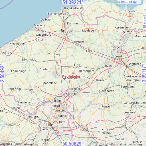
Meulebeke GPS coordinates[2]
50° 57' 4.896" North, 3° 17' 16.944" East
| Map corner | latitude | longitude |
|---|---|---|
| Upper-left | 51.39221°, | 2.58492° |
| Center: | 50.95136°, | 3.28804° |
| Lower-right: | 50.50629°, | 3.99117° |
| Map W x H: | 98.5×98.5 km | = 61.2×61.2mi |
| max Lat: | 51.46791° ⇑34.1% North |
| Meulebeke: | 50.95136° |
| min Lat: | ⇓65.9% South 49.53771° |
| min Long | Meulebeke | max Long |
| 2.59368° | 3.28804° | 6.25749° |
| W 9.6%⇐ | ⇒90.4% E |
Elevation
Elevation of Meulebeke is 19 m = 62 ft, and this is 80.5 m = 264 ft below average elevation for this country.
| Max E: |
582 m = 1909 ft | 73.1% |
| Avg. | 99.5 m = 326 ft | |
| Meulebeke | 19 m = 62 ft | |
Min E: |
1 m = 3 ft | 26.9% |
See also: Belgium elevation on elevation.city.
Geographical zone
Meulebeke is located in North temperate zone (between Tropic of Cancer and the Arctic Circle). Distance of this North polar circle is 1735.9 km =1078.6 mi to North.| Distance of | km | miles | from Meulebeke |
|---|---|---|---|
| North Pole | 4341.8 | 2697.9 | to North |
| Arctic Circle | 1735.9 | 1078.6 | to North |
| Tropic Cancer | 3059.3 | 1901 | to South |
| Equator | 5665.3 | 3520.3 | to South |


Nearby cities:
15 places around Meulebeke: (largest is in red/bold)
• Ardooie
6.9 km =4.3 mi,  293°
293°
• Deerlijk
11.8 km =7.3 mi,  156°
156°
• Dentergem
9.1 km =5.7 mi,  80°
80°
• Harelbeke
11 km =6.8 mi,  172°
172°
• Ingelmunster
4.1 km =2.5 mi,  213°
213°
• Izegem
6.7 km =4.2 mi,  231°
231°
• Kuurne
11.1 km =6.9 mi,  182°
182°
• Lendelede
8.1 km =5 mi, 206°
• Oostrozebeke
4.9 km =3 mi,  134°
134°
• Pittem
4.9 km =3 mi,  339°
339°
• Roeselare
11.6 km =7.2 mi,  267°
267°
• Tielt
6 km =3.7 mi,  27°
27°
• Wielsbeke
7.9 km =4.9 mi,  136°
136°
• Wingene
11.9 km =7.4 mi,  355°
355°
• Zulte
11.8 km =7.3 mi,  107°
107°
Sources, notices
• [Note1] Compared only with cities in Belgium existing in our database
• [Src1] Map data: © OpenStreetMap contributors (CC-BY-SA)
• [Src2] Other city data from geonames.org with taken over terms of usage.
• [Src3] Geographical zone / Annual Mean Temperature by Robert A. Rohde @ Wikipedia
