Tielt geodata
Tielt (Flanders) is a seat of a third-order administrative division; located in Belgium in Europe/Brussels (GMT+2) time zone. With population of 19,299 people, there are 129 cities with bigger population in this country. Compared to other cities in Belgium, 70.4% of cities are located further ↓South; 89.9% of cities are located further →East and 52% of cities have higher elevation than Tielt. Note1
Administrative division(s):
- Level 1: Flanders
- Level 2: Provincie West-Vlaanderen
- Level 3: Arrondissement Tielt
- Level 4: Tielt


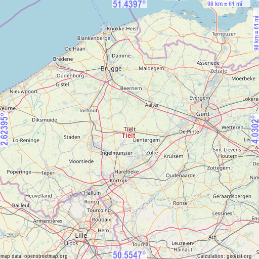
Tielt GPS coordinates[2]
50° 59' 57.516" North, 3° 19' 37.452" East
| Map corner | latitude | longitude |
|---|---|---|
| Upper-left | 51.4397°, | 2.62395° |
| Center: | 50.99931°, | 3.32707° |
| Lower-right: | 50.5547°, | 4.0302° |
| Map W x H: | 98.4×98.4 km | = 61.1×61.1mi |
| max Lat: | 51.46791° ⇑29.6% North |
| Tielt: | 50.99931° |
| min Lat: | ⇓70.4% South 49.53771° |
| min Long | Tielt | max Long |
| 2.59368° | 3.32707° | 6.25749° |
| W 10.1%⇐ | ⇒89.9% E |
Elevation
Elevation of Tielt is 46 m = 151 ft, and this is 53.5 m = 176 ft below average elevation for this country.
| Max E: |
582 m = 1909 ft | 52% |
| Avg. | 99.5 m = 326 ft | |
| Tielt | 46 m = 151 ft | |
Min E: |
1 m = 3 ft | 48% |
See also: Belgium elevation on elevation.city.
Geographical zone
Tielt is located in North temperate zone (between Tropic of Cancer and the Arctic Circle). Distance of this North polar circle is 1730.6 km =1075.3 mi to North.| Distance of | km | miles | from Tielt |
|---|---|---|---|
| North Pole | 4336.5 | 2694.6 | to North |
| Arctic Circle | 1730.6 | 1075.3 | to North |
| Tropic Cancer | 3064.7 | 1904.3 | to South |
| Equator | 5670.6 | 3523.5 | to South |


Nearby cities:
15 places around Tielt: (largest is in red/bold)
• Aalter
13.1 km =8.1 mi,  39°
39°
• Ardooie
9.5 km =5.9 mi,  253°
253°
• Dentergem
7.4 km =4.6 mi,  121°
121°
• Ingelmunster
10.1 km =6.3 mi,  209°
209°
• Izegem
12.4 km =7.7 mi,  219°
219°
• Lendelede
14.1 km =8.8 mi, 206°
• Lichtervelde
13 km =8.1 mi,  286°
286°
• Meulebeke
6 km =3.7 mi, 207°
• Oostrozebeke
8.7 km =5.4 mi,  174°
174°
• Pittem
4.5 km =2.8 mi,  260°
260°
• Ruiselede
6.5 km =4 mi,  45°
45°
• Waregem
14.1 km =8.8 mi,  150°
150°
• Wielsbeke
11.4 km =7.1 mi, 165°
• Wingene
7.5 km =4.7 mi,  330°
330°
• Zulte
12.3 km =7.6 mi,  136°
136°
Sources, notices
• [Note1] Compared only with cities in Belgium existing in our database
• [Src1] Map data: © OpenStreetMap contributors (CC-BY-SA)
• [Src2] Other city data from geonames.org with taken over terms of usage.
• [Src3] Geographical zone / Annual Mean Temperature by Robert A. Rohde @ Wikipedia
