Neufchâteau geodata
Neufchâteau (Wallonia) is a seat of a third-order administrative division; located in Belgium in Europe/Brussels (GMT+2) time zone. With population of 6,416 people, there are 413 cities with bigger population in this country. Compared to other cities in Belgium, 96.8% of cities are located further ↑North; 81.9% of cities are located further ←West and 97.5% of cities have lower elevation than Neufchâteau. Note1
Administrative division(s):
- Level 1: Wallonia
- Level 2: Province du Luxembourg
- Level 3: Arrondissement de Neufchâteau
- Level 4: Neufchâteau


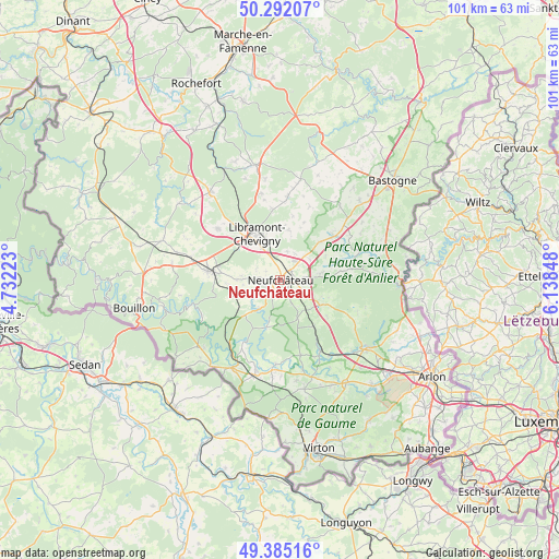
Neufchâteau GPS coordinates[2]
49° 50' 26.664" North, 5° 26' 7.26" East
| Map corner | latitude | longitude |
|---|---|---|
| Upper-left | 50.29207°, | 4.73223° |
| Center: | 49.84074°, | 5.43535° |
| Lower-right: | 49.38516°, | 6.13848° |
| Map W x H: | 100.8×100.8 km | = 62.6×62.6mi |
| max Lat: | 51.46791° ⇑96.8% North |
| Neufchâteau: | 49.84074° |
| min Lat: | ⇓3.2% South 49.53771° |
| min Long | Neufchâteau | max Long |
| 2.59368° | 5.43535° | 6.25749° |
| W 81.9%⇐ | ⇒18.1% E |
Elevation
Elevation of Neufchâteau is 424 m = 1391 ft, and this is 324.5 m = 1065 ft above average elevation for this country.
| Max E: |
582 m = 1909 ft | 2.5% |
| Neufchâteau | 424 m 1391 ft | |
| Avg. | 99.5 m = 326 ft | |
Min E: |
1 m = 3 ft | 97.5% |
See also: Belgium elevation on elevation.city.
Geographical zone
Neufchâteau is located in North temperate zone (between Tropic of Cancer and the Arctic Circle). Distance of this North polar circle is 1859.4 km =1155.4 mi to North.| Distance of | km | miles | from Neufchâteau |
|---|---|---|---|
| North Pole | 4465.3 | 2774.6 | to North |
| Arctic Circle | 1859.4 | 1155.4 | to North |
| Tropic Cancer | 2935.9 | 1824.3 | to South |
| Equator | 5541.8 | 3443.5 | to South |


Nearby cities:
15 places around Neufchâteau: (largest is in red/bold)
• Bertrix
13 km =8.1 mi,  277°
277°
• Chiny
13.2 km =8.2 mi,  210°
210°
• Fauvillers
16.4 km =10.2 mi,  85°
85°
• Florenville
18.2 km =11.3 mi, 210°
• Habay-la-Vieille
18.6 km =11.6 mi,  134°
134°
• Herbeumont
15.8 km =9.8 mi,  245°
245°
• Libin
20.2 km =12.6 mi,  320°
320°
• Léglise
8.6 km =5.3 mi,  122°
122°
• Martelange
21.6 km =13.4 mi, 92°
• Paliseul
22.6 km =14 mi,  288°
288°
• Saint-Hubert
21.1 km =13.1 mi,  348°
348°
• Sainte-Ode
20.5 km =12.7 mi,  17°
17°
• Tintigny
18.4 km =11.4 mi,  162°
162°
• Vaux-sur-Sûre
12.9 km =8 mi,  52°
52°
• Étalle
22 km =13.7 mi,  147°
147°
Sources, notices
• [Note1] Compared only with cities in Belgium existing in our database
• [Src1] Map data: © OpenStreetMap contributors (CC-BY-SA)
• [Src2] Other city data from geonames.org with taken over terms of usage.
• [Src3] Geographical zone / Annual Mean Temperature by Robert A. Rohde @ Wikipedia
