Saint-Hubert geodata
Saint-Hubert (Wallonia) is a populated place; located in Belgium in Europe/Brussels (GMT+2) time zone. With population of 5,538 people, there are 434 cities with bigger population in this country. Compared to other cities in Belgium, 94.8% of cities are located further ↑North; 80% of cities are located further ←West and 98% of cities have lower elevation than Saint-Hubert. Note1
Administrative division(s):
- Level 1: Wallonia
- Level 2: Province du Luxembourg
- Level 3: Arrondissement de Neufchâteau
- Level 4: Saint-Hubert


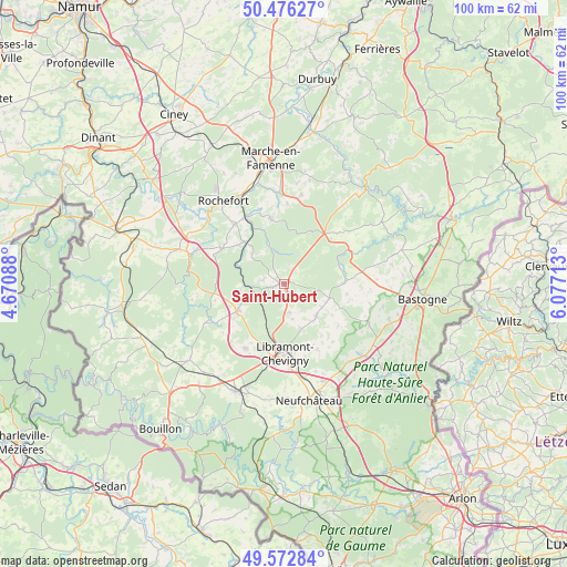
Saint-Hubert GPS coordinates[2]
50° 1' 36.048" North, 5° 22' 26.436" East
| Map corner | latitude | longitude |
|---|---|---|
| Upper-left | 50.47627°, | 4.67088° |
| Center: | 50.02668°, | 5.37401° |
| Lower-right: | 49.57284°, | 6.07713° |
| Map W x H: | 100.5×100.4 km | = 62.4×62.4mi |
| max Lat: | 51.46791° ⇑94.8% North |
| Saint-Hubert: | 50.02668° |
| min Lat: | ⇓5.2% South 49.53771° |
| min Long | Saint-Hubert | max Long |
| 2.59368° | 5.37401° | 6.25749° |
| W 80%⇐ | ⇒20% E |
Elevation
Elevation of Saint-Hubert is 432 m = 1417 ft, and this is 332.5 m = 1091 ft above average elevation for this country.
| Max E: |
582 m = 1909 ft | 2% |
| Saint-Hubert | 432 m 1417 ft | |
| Avg. | 99.5 m = 326 ft | |
Min E: |
1 m = 3 ft | 98% |
See also: Belgium elevation on elevation.city.
Geographical zone
Saint-Hubert is located in North temperate zone (between Tropic of Cancer and the Arctic Circle). Distance of this North polar circle is 1838.7 km =1142.5 mi to North.| Distance of | km | miles | from Saint-Hubert |
|---|---|---|---|
| North Pole | 4444.6 | 2761.7 | to North |
| Arctic Circle | 1838.7 | 1142.5 | to North |
| Tropic Cancer | 2956.5 | 1837.1 | to South |
| Equator | 5562.4 | 3456.3 | to South |


Nearby cities:
15 places around Saint-Hubert: (largest is in red/bold)
• Bertogne
21.8 km =13.5 mi,  73°
73°
• Bertrix
20.8 km =12.9 mi,  204°
204°
• Daverdisse
18.3 km =11.4 mi,  268°
268°
• La Roche-en-Ardenne
22.6 km =14 mi,  39°
39°
• Libin
9.8 km =6.1 mi,  238°
238°
• Marche-en-Famenne
22.4 km =13.9 mi,  354°
354°
• Nassogne
11.5 km =7.1 mi, 348°
• Neufchâteau
21.1 km =13.1 mi,  168°
168°
• Paliseul
21.9 km =13.6 mi,  231°
231°
• Rochefort
18.7 km =11.6 mi,  324°
324°
• Sainte-Ode
10.4 km =6.5 mi,  95°
95°
• Tellin
12.7 km =7.9 mi,  297°
297°
• Tenneville
13.4 km =8.3 mi,  55°
55°
• Vaux-sur-Sûre
19.5 km =12.1 mi,  131°
131°
• Wellin
19.5 km =12.1 mi,  288°
288°
Sources, notices
• [Note1] Compared only with cities in Belgium existing in our database
• [Src1] Map data: © OpenStreetMap contributors (CC-BY-SA)
• [Src2] Other city data from geonames.org with taken over terms of usage.
• [Src3] Geographical zone / Annual Mean Temperature by Robert A. Rohde @ Wikipedia
