La Hulpe geodata
La Hulpe (Wallonia) is a populated place; located in Belgium in Europe/Brussels (GMT+2) time zone. With population of 7,415 people, there are 388 cities with bigger population in this country. Compared to other cities in Belgium, 56% of cities are located further ↑North; 55.1% of cities are located further →East and 62.3% of cities have lower elevation than La Hulpe. Note1
Administrative division(s):
- Level 1: Wallonia
- Level 2: Province du Brabant Wallon
- Level 3: Arrondissement de Nivelles
- Level 4: La Hulpe


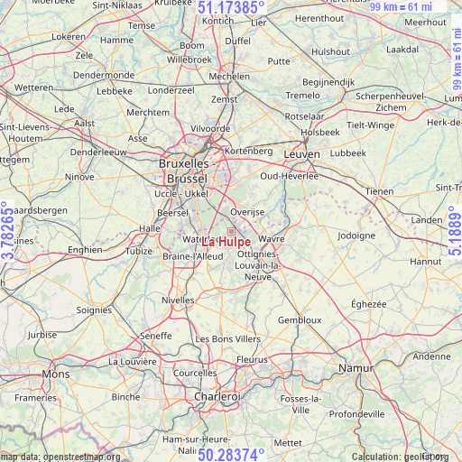
La Hulpe GPS coordinates[2]
50° 43' 51.276" North, 4° 29' 8.772" East
| Map corner | latitude | longitude |
|---|---|---|
| Upper-left | 51.17385°, | 3.78265° |
| Center: | 50.73091°, | 4.48577° |
| Lower-right: | 50.28374°, | 5.1889° |
| Map W x H: | 99×99 km | = 61.5×61.5mi |
| max Lat: | 51.46791° ⇑56% North |
| La Hulpe: | 50.73091° |
| min Lat: | ⇓44% South 49.53771° |
| min Long | La Hulpe | max Long |
| 2.59368° | 4.48577° | 6.25749° |
| W 44.9%⇐ | ⇒55.1% E |
Elevation
Elevation of La Hulpe is 86 m = 282 ft, and this is 13.5 m = 44 ft below average elevation for this country.
| Max E: |
582 m = 1909 ft | 37.7% |
| Avg. | 99.5 m = 326 ft | |
| La Hulpe | 86 m = 282 ft | |
Min E: |
1 m = 3 ft | 62.3% |
See also: Belgium elevation on elevation.city.
Geographical zone
La Hulpe is located in North temperate zone (between Tropic of Cancer and the Arctic Circle). Distance of this North polar circle is 1760.4 km =1093.9 mi to North.| Distance of | km | miles | from La Hulpe |
|---|---|---|---|
| North Pole | 4366.3 | 2713.1 | to North |
| Arctic Circle | 1760.4 | 1093.9 | to North |
| Tropic Cancer | 3034.8 | 1885.7 | to South |
| Equator | 5640.7 | 3505 | to South |


Nearby cities:
15 places around La Hulpe: (largest is in red/bold)
• Basse Lasne
4 km =2.5 mi,  173°
173°
• Braine-l'Alleud
9.8 km =6.1 mi,  237°
237°
• Court-Saint-Étienne
12.3 km =7.6 mi,  151°
151°
• Hoeilaart
4.2 km =2.6 mi,  343°
343°
• Huldenberg
9.4 km =5.8 mi,  46°
46°
• Linkebeek
11.2 km =7 mi,  291°
291°
• Louvain-la-Neuve
11.4 km =7.1 mi,  127°
127°
• Ottignies
9.3 km =5.8 mi,  141°
141°
• Overijse
5.9 km =3.7 mi,  35°
35°
• Rixensart
3.5 km =2.2 mi, 126°
• Sint-Genesius-Rode
9.2 km =5.7 mi,  280°
280°
• Tervuren
10.5 km =6.5 mi,  10°
10°
• Waterloo
6.4 km =4 mi,  253°
253°
• Wavre
8.3 km =5.2 mi,  100°
100°
• Wezembeek-Oppem
12.1 km =7.5 mi,  2°
2°
Sources, notices
• [Note1] Compared only with cities in Belgium existing in our database
• [Src1] Map data: © OpenStreetMap contributors (CC-BY-SA)
• [Src2] Other city data from geonames.org with taken over terms of usage.
• [Src3] Geographical zone / Annual Mean Temperature by Robert A. Rohde @ Wikipedia
