Sint-Genesius-Rode geodata
Sint-Genesius-Rode (Flanders) is a populated place; located in Belgium in Europe/Brussels (GMT+2) time zone. With population of 17,990 people, there are 142 cities with bigger population in this country. Compared to other cities in Belgium, 54% of cities are located further ↑North; 61.4% of cities are located further →East and 60.8% of cities have lower elevation than Sint-Genesius-Rode. Note1
Administrative division(s):
- Level 1: Flanders
- Level 2: Provincie Vlaams-Brabant
- Level 3: Arrondissement Halle-Vilvoorde
- Level 4: Sint-Genesius-Rode


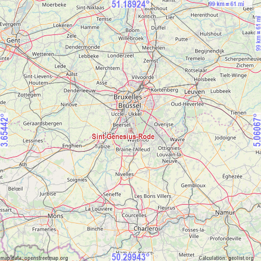
Sint-Genesius-Rode GPS coordinates[2]
50° 44' 47.22" North, 4° 21' 27.144" East
| Map corner | latitude | longitude |
|---|---|---|
| Upper-left | 51.18924°, | 3.65442° |
| Center: | 50.74645°, | 4.35754° |
| Lower-right: | 50.29943°, | 5.06067° |
| Map W x H: | 98.9×98.9 km | = 61.5×61.5mi |
| max Lat: | 51.46791° ⇑54% North |
| Sint-Genesius-Rode: | 50.74645° |
| min Lat: | ⇓46% South 49.53771° |
| min Long | Sint-Genesius-R | max Long |
| 2.59368° | 4.35754° | 6.25749° |
| W 38.6%⇐ | ⇒61.4% E |
Elevation
Elevation of Sint-Genesius-Rode is 83 m = 272 ft, and this is 16.5 m = 54 ft below average elevation for this country.
| Max E: |
582 m = 1909 ft | 39.2% |
| Avg. | 99.5 m = 326 ft | |
| Sint-Genesius-Rode | 83 m = 272 ft | |
Min E: |
1 m = 3 ft | 60.8% |
See also: Belgium elevation on elevation.city.
Geographical zone
Sint-Genesius-Rode is located in North temperate zone (between Tropic of Cancer and the Arctic Circle). Distance of this North polar circle is 1758.7 km =1092.8 mi to North.| Distance of | km | miles | from Sint-Genesius-Rode |
|---|---|---|---|
| North Pole | 4364.6 | 2712 | to North |
| Arctic Circle | 1758.7 | 1092.8 | to North |
| Tropic Cancer | 3036.6 | 1886.9 | to South |
| Equator | 5642.5 | 3506.1 | to South |


Nearby cities:
15 places around Sint-Genesius-Rode: (largest is in red/bold)
• Basse Lasne
11.1 km =6.9 mi,  121°
121°
• Beersel
4.6 km =2.9 mi,  298°
298°
• Braine-l'Alleud
7 km =4.3 mi,  174°
174°
• Braine-le-Château
9.5 km =5.9 mi,  218°
218°
• Brussels
11.6 km =7.2 mi,  356°
356°
• Drogenbos
5.5 km =3.4 mi,  326°
326°
• Halle
8.8 km =5.5 mi,  260°
260°
• Hoeilaart
8.1 km =5 mi,  73°
73°
• La Hulpe
9.2 km =5.7 mi,  100°
100°
• Linkebeek
2.8 km =1.7 mi, 328°
• Overijse
12.8 km =8 mi,  76°
76°
• Rixensart
12.4 km =7.7 mi,  107°
107°
• Sint-Pieters-Leeuw
8.8 km =5.5 mi,  294°
294°
• Tubize
12.7 km =7.9 mi,  240°
240°
• Waterloo
4.6 km =2.9 mi,  140°
140°
Sources, notices
• [Note1] Compared only with cities in Belgium existing in our database
• [Src1] Map data: © OpenStreetMap contributors (CC-BY-SA)
• [Src2] Other city data from geonames.org with taken over terms of usage.
• [Src3] Geographical zone / Annual Mean Temperature by Robert A. Rohde @ Wikipedia
