Louvain-la-Neuve geodata
Louvain-la-Neuve (Wallonia) is a populated place; located in Belgium in Europe/Brussels (GMT+2) time zone. With population of 29,521 people, there are 64 cities with bigger population in this country. Compared to other cities in Belgium, 61.9% of cities are located further ↑North; 51.8% of cities are located further ←West and 69% of cities have lower elevation than Louvain-la-Neuve. Note1
Administrative division(s):
- Level 1: Wallonia
- Level 2: Province du Brabant Wallon
- Level 3: Arrondissement de Nivelles
- Level 4: Ottignies-Louvain-la-Neuve


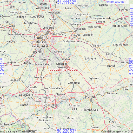
Louvain-la-Neuve GPS coordinates[2]
50° 40' 5.844" North, 4° 36' 51.948" East
| Map corner | latitude | longitude |
|---|---|---|
| Upper-left | 51.11182°, | 3.91131° |
| Center: | 50.66829°, | 4.61443° |
| Lower-right: | 50.22053°, | 5.31756° |
| Map W x H: | 99.1×99.1 km | = 61.6×61.6mi |
| max Lat: | 51.46791° ⇑61.9% North |
| Louvain-la-Neuve: | 50.66829° |
| min Lat: | ⇓38.1% South 49.53771° |
| min Long | Louvain-la-Neuv | max Long |
| 2.59368° | 4.61443° | 6.25749° |
| W 51.8%⇐ | ⇒48.2% E |
Elevation
Elevation of Louvain-la-Neuve is 117 m = 384 ft, and this is 17.5 m = 57 ft above average elevation for this country.
| Max E: |
582 m = 1909 ft | 31% |
| Louvain-la-Neuve | 117 m 384 ft | |
| Avg. | 99.5 m = 326 ft | |
Min E: |
1 m = 3 ft | 69% |
See also: Belgium elevation on elevation.city.
Geographical zone
Louvain-la-Neuve is located in North temperate zone (between Tropic of Cancer and the Arctic Circle). Distance of this North polar circle is 1767.4 km =1098.2 mi to North.| Distance of | km | miles | from Louvain-la-Neuve |
|---|---|---|---|
| North Pole | 4373.3 | 2717.4 | to North |
| Arctic Circle | 1767.4 | 1098.2 | to North |
| Tropic Cancer | 3027.9 | 1881.4 | to South |
| Equator | 5633.8 | 3500.7 | to South |


Nearby cities:
15 places around Louvain-la-Neuve: (largest is in red/bold)
• Basse Lasne
9.1 km =5.7 mi,  289°
289°
• Chastre
7.6 km =4.7 mi,  169°
169°
• Chastre-Villeroux-Blanmont
6.9 km =4.3 mi,  163°
163°
• Chaumont-Gistoux
7.6 km =4.7 mi,  82°
82°
• Court-Saint-Étienne
5 km =3.1 mi,  220°
220°
• Genappe
13.1 km =8.1 mi,  241°
241°
• Grez-Doiceau
9.8 km =6.1 mi,  36°
36°
• Incourt
13.2 km =8.2 mi, 78°
• La Hulpe
11.4 km =7.1 mi,  307°
307°
• Mont-Saint-Guibert
3.8 km =2.4 mi,  184°
184°
• Ottignies
3.4 km =2.1 mi,  264°
264°
• Overijse
13.1 km =8.1 mi,  334°
334°
• Rixensart
8 km =5 mi, 307°
• Walhain-Saint-Paul
7.5 km =4.7 mi,  128°
128°
• Wavre
5.5 km =3.4 mi,  350°
350°
Sources, notices
• [Note1] Compared only with cities in Belgium existing in our database
• [Src1] Map data: © OpenStreetMap contributors (CC-BY-SA)
• [Src2] Other city data from geonames.org with taken over terms of usage.
• [Src3] Geographical zone / Annual Mean Temperature by Robert A. Rohde @ Wikipedia
