Linkebeek geodata
Linkebeek (Flanders) is a populated place; located in Belgium in Europe/Brussels (GMT+2) time zone. With population of 4,823 people, there are 462 cities with bigger population in this country. Compared to other cities in Belgium, 52.2% of cities are located further ↑North; 62.3% of cities are located further →East and 61.7% of cities have lower elevation than Linkebeek. Note1
Administrative division(s):
- Level 1: Flanders
- Level 2: Provincie Vlaams-Brabant
- Level 3: Arrondissement Halle-Vilvoorde
- Level 4: Linkebeek


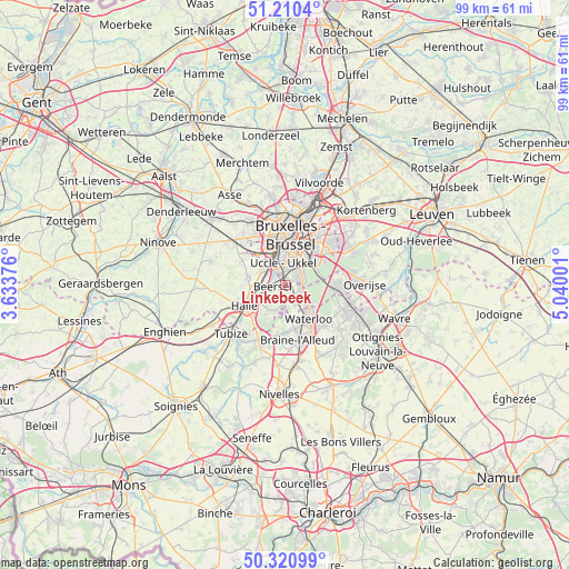
Linkebeek GPS coordinates[2]
50° 46' 4.116" North, 4° 20' 12.768" East
| Map corner | latitude | longitude |
|---|---|---|
| Upper-left | 51.2104°, | 3.63376° |
| Center: | 50.76781°, | 4.33688° |
| Lower-right: | 50.32099°, | 5.04001° |
| Map W x H: | 98.9×98.9 km | = 61.5×61.5mi |
| max Lat: | 51.46791° ⇑52.2% North |
| Linkebeek: | 50.76781° |
| min Lat: | ⇓47.8% South 49.53771° |
| min Long | Linkebeek | max Long |
| 2.59368° | 4.33688° | 6.25749° |
| W 37.7%⇐ | ⇒62.3% E |
Elevation
Elevation of Linkebeek is 85 m = 279 ft, and this is 14.5 m = 48 ft below average elevation for this country.
| Max E: |
582 m = 1909 ft | 38.3% |
| Avg. | 99.5 m = 326 ft | |
| Linkebeek | 85 m = 279 ft | |
Min E: |
1 m = 3 ft | 61.7% |
See also: Belgium elevation on elevation.city.
Geographical zone
Linkebeek is located in North temperate zone (between Tropic of Cancer and the Arctic Circle). Distance of this North polar circle is 1756.3 km =1091.3 mi to North.| Distance of | km | miles | from Linkebeek |
|---|---|---|---|
| North Pole | 4362.2 | 2710.5 | to North |
| Arctic Circle | 1756.3 | 1091.3 | to North |
| Tropic Cancer | 3038.9 | 1888.3 | to South |
| Equator | 5644.9 | 3507.6 | to South |


Nearby cities:
15 places around Linkebeek: (largest is in red/bold)
• Beersel
2.6 km =1.6 mi,  265°
265°
• Braine-l'Alleud
9.6 km =6 mi,  166°
166°
• Braine-le-Château
10.7 km =6.6 mi,  204°
204°
• Brussels
9.2 km =5.7 mi,  5°
5°
• Dilbeek
10.4 km =6.5 mi,  328°
328°
• Drogenbos
2.7 km =1.7 mi,  324°
324°
• Halle
8.1 km =5 mi,  242°
242°
• Hoeilaart
9.2 km =5.7 mi,  90°
90°
• La Hulpe
11.2 km =7 mi,  111°
111°
• Pepingen
12.5 km =7.8 mi, 265°
• Sint-Genesius-Rode
2.8 km =1.7 mi,  148°
148°
• Sint-Martens-Lennik
12.7 km =7.9 mi,  292°
292°
• Sint-Pieters-Leeuw
6.7 km =4.2 mi,  280°
280°
• Tubize
12.9 km =8 mi,  228°
228°
• Waterloo
7.4 km =4.6 mi,  143°
143°
Sources, notices
• [Note1] Compared only with cities in Belgium existing in our database
• [Src1] Map data: © OpenStreetMap contributors (CC-BY-SA)
• [Src2] Other city data from geonames.org with taken over terms of usage.
• [Src3] Geographical zone / Annual Mean Temperature by Robert A. Rohde @ Wikipedia
