Jurbise geodata
Jurbise (Wallonia) is a populated place; located in Belgium in Europe/Brussels (GMT+2) time zone. With population of 9,483 people, there are 316 cities with bigger population in this country. Compared to other cities in Belgium, 75.1% of cities are located further ↑North; 76.4% of cities are located further →East and 57.6% of cities have lower elevation than Jurbise. Note1
Administrative division(s):
- Level 1: Wallonia
- Level 2: Province du Hainaut
- Level 3: Arrondissement de Mons
- Level 4: Jurbise


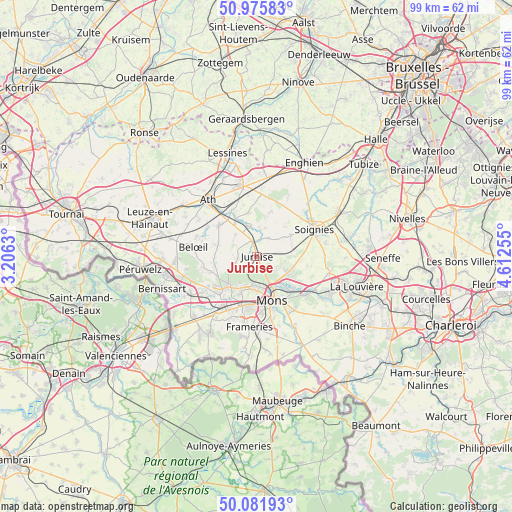
Jurbise GPS coordinates[2]
50° 31' 51.6" North, 3° 54' 33.912" East
| Map corner | latitude | longitude |
|---|---|---|
| Upper-left | 50.97583°, | 3.2063° |
| Center: | 50.531°, | 3.90942° |
| Lower-right: | 50.08193°, | 4.61255° |
| Map W x H: | 99.4×99.4 km | = 61.8×61.8mi |
| max Lat: | 51.46791° ⇑75.1% North |
| Jurbise: | 50.531° |
| min Lat: | ⇓24.9% South 49.53771° |
| min Long | Jurbise | max Long |
| 2.59368° | 3.90942° | 6.25749° |
| W 23.6%⇐ | ⇒76.4% E |
Elevation
Elevation of Jurbise is 70 m = 230 ft, and this is 29.5 m = 97 ft below average elevation for this country.
| Max E: |
582 m = 1909 ft | 42.4% |
| Avg. | 99.5 m = 326 ft | |
| Jurbise | 70 m = 230 ft | |
Min E: |
1 m = 3 ft | 57.6% |
See also: Belgium elevation on elevation.city.
Geographical zone
Jurbise is located in North temperate zone (between Tropic of Cancer and the Arctic Circle). Distance of this North polar circle is 1782.7 km =1107.7 mi to North.| Distance of | km | miles | from Jurbise |
|---|---|---|---|
| North Pole | 4388.5 | 2726.9 | to North |
| Arctic Circle | 1782.7 | 1107.7 | to North |
| Tropic Cancer | 3012.6 | 1871.9 | to South |
| Equator | 5618.5 | 3491.2 | to South |


Nearby cities:
15 places around Jurbise: (largest is in red/bold)
• Ath
14.3 km =8.9 mi,  319°
319°
• Beloeil
12.5 km =7.8 mi,  279°
279°
• Boussu
13.5 km =8.4 mi,  217°
217°
• Brugelette
8.2 km =5.1 mi,  331°
331°
• Chasse Royale
11.8 km =7.3 mi,  165°
165°
• Chièvres
9.6 km =6 mi,  311°
311°
• Colfontaine
13.5 km =8.4 mi,  196°
196°
• Frameries
14 km =8.7 mi,  183°
183°
• Lens
3 km =1.9 mi,  346°
346°
• Mons
9.1 km =5.7 mi,  160°
160°
• Quaregnon
10.5 km =6.5 mi, 197°
• Roeulx
14.6 km =9.1 mi,  102°
102°
• Saint-Ghislain
11.2 km =7 mi,  214°
214°
• Silly
13.1 km =8.1 mi,  4°
4°
• Soignies
12.6 km =7.8 mi,  64°
64°
Sources, notices
• [Note1] Compared only with cities in Belgium existing in our database
• [Src1] Map data: © OpenStreetMap contributors (CC-BY-SA)
• [Src2] Other city data from geonames.org with taken over terms of usage.
• [Src3] Geographical zone / Annual Mean Temperature by Robert A. Rohde @ Wikipedia
