Chasse Royale geodata
Chasse Royale (Wallonia) is a seat of government of a political entity; located in Belgium in Europe/Brussels (GMT+2) time zone. In our database, there are 548 cities with bigger population. Compared to other cities in Belgium, 81.6% of cities are located further ↑North; 75.6% of cities are located further →East and 55.2% of cities have higher elevation than Chasse Royale. Note1
Administrative division(s):
- Level 1: Wallonia
- Level 2: Province du Hainaut
- Level 3: Arrondissement de Mons
- Level 4: Mons


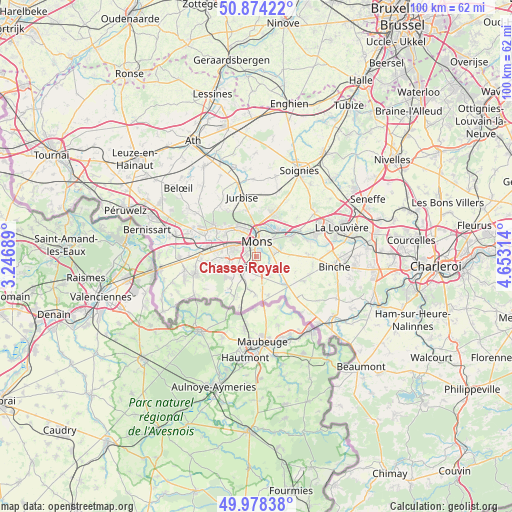
Chasse Royale GPS coordinates[2]
50° 25' 42.312" North, 3° 57' 0.036" East
| Map corner | latitude | longitude |
|---|---|---|
| Upper-left | 50.87422°, | 3.24689° |
| Center: | 50.42842°, | 3.95001° |
| Lower-right: | 49.97838°, | 4.65314° |
| Map W x H: | 99.6×99.6 km | = 61.9×61.9mi |
| max Lat: | 51.46791° ⇑81.6% North |
| Chasse Royale: | 50.42842° |
| min Lat: | ⇓18.4% South 49.53771° |
| min Long | Chasse Royale | max Long |
| 2.59368° | 3.95001° | 6.25749° |
| W 24.4%⇐ | ⇒75.6% E |
Elevation
Elevation of Chasse Royale is 42 m = 138 ft, and this is 57.5 m = 189 ft below average elevation for this country.
| Max E: |
582 m = 1909 ft | 55.2% |
| Avg. | 99.5 m = 326 ft | |
| Chasse Royale | 42 m = 138 ft | |
Min E: |
1 m = 3 ft | 44.8% |
See also: Belgium elevation on elevation.city.
Geographical zone
Chasse Royale is located in North temperate zone (between Tropic of Cancer and the Arctic Circle). Distance of this North polar circle is 1794.1 km =1114.8 mi to North.| Distance of | km | miles | from Chasse Royale |
|---|---|---|---|
| North Pole | 4399.9 | 2734 | to North |
| Arctic Circle | 1794.1 | 1114.8 | to North |
| Tropic Cancer | 3001.2 | 1864.9 | to South |
| Equator | 5607.1 | 3484.1 | to South |


Nearby cities:
15 places around Chasse Royale: (largest is in red/bold)
• Binche
15.3 km =9.5 mi,  97°
97°
• Boussu
11 km =6.8 mi,  273°
273°
• Colfontaine
6.9 km =4.3 mi,  256°
256°
• Dour
12.7 km =7.9 mi,  253°
253°
• Erquelinnes
17.7 km =11 mi,  139°
139°
• Estinnes-au-Val
11.2 km =7 mi, 100°
• Frameries
4.6 km =2.9 mi,  236°
236°
• Jurbise
11.8 km =7.3 mi,  345°
345°
• La Louvière
18 km =11.2 mi,  68°
68°
• Lens
14.7 km =9.1 mi, 345°
• Mons
2.9 km =1.8 mi,  3°
3°
• Quaregnon
6.2 km =3.9 mi,  282°
282°
• Quévy-le-Petit
6.7 km =4.2 mi,  188°
188°
• Roeulx
14.2 km =8.8 mi,  53°
53°
• Saint-Ghislain
9.5 km =5.9 mi, 283°
Sources, notices
• [Note1] Compared only with cities in Belgium existing in our database
• [Src1] Map data: © OpenStreetMap contributors (CC-BY-SA)
• [Src2] Other city data from geonames.org with taken over terms of usage.
• [Src3] Geographical zone / Annual Mean Temperature by Robert A. Rohde @ Wikipedia
