Saint-Ghislain geodata
Saint-Ghislain (Wallonia) is a populated place; located in Belgium in Europe/Brussels (GMT+2) time zone. With population of 22,500 people, there are 98 cities with bigger population in this country. Compared to other cities in Belgium, 80% of cities are located further ↑North; 79.2% of cities are located further →East and 64.3% of cities have higher elevation than Saint-Ghislain. Note1
Administrative division(s):
- Level 1: Wallonia
- Level 2: Province du Hainaut
- Level 3: Arrondissement de Mons
- Level 4: Saint-Ghislain


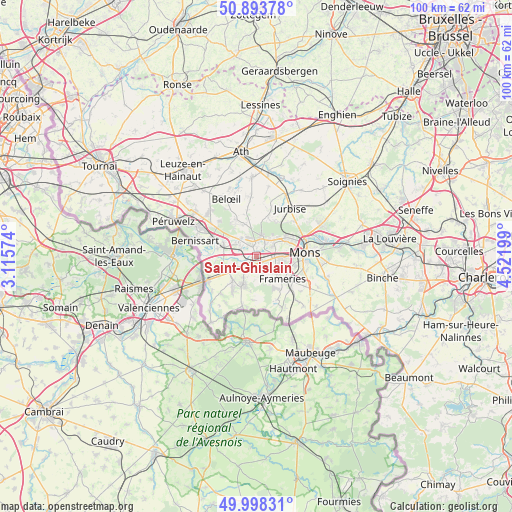
Saint-Ghislain GPS coordinates[2]
50° 26' 53.376" North, 3° 49' 7.896" East
| Map corner | latitude | longitude |
|---|---|---|
| Upper-left | 50.89378°, | 3.11574° |
| Center: | 50.44816°, | 3.81886° |
| Lower-right: | 49.99831°, | 4.52199° |
| Map W x H: | 99.6×99.6 km | = 61.9×61.9mi |
| max Lat: | 51.46791° ⇑80% North |
| Saint-Ghislain: | 50.44816° |
| min Lat: | ⇓20% South 49.53771° |
| min Long | Saint-Ghislain | max Long |
| 2.59368° | 3.81886° | 6.25749° |
| W 20.8%⇐ | ⇒79.2% E |
Elevation
Elevation of Saint-Ghislain is 27 m = 89 ft, and this is 72.5 m = 238 ft below average elevation for this country.
| Max E: |
582 m = 1909 ft | 64.3% |
| Avg. | 99.5 m = 326 ft | |
| Saint-Ghislain | 27 m = 89 ft | |
Min E: |
1 m = 3 ft | 35.7% |
See also: Belgium elevation on elevation.city.
Geographical zone
Saint-Ghislain is located in North temperate zone (between Tropic of Cancer and the Arctic Circle). Distance of this North polar circle is 1791.9 km =1113.4 mi to North.| Distance of | km | miles | from Saint-Ghislain |
|---|---|---|---|
| North Pole | 4397.8 | 2732.7 | to North |
| Arctic Circle | 1791.9 | 1113.4 | to North |
| Tropic Cancer | 3003.4 | 1866.2 | to South |
| Equator | 5609.3 | 3485.5 | to South |


Nearby cities:
15 places around Saint-Ghislain: (largest is in red/bold)
• Beloeil
12.8 km =8 mi,  332°
332°
• Bernissart
12.3 km =7.6 mi,  283°
283°
• Boussu
2.3 km =1.4 mi,  228°
228°
• Chasse Royale
9.5 km =5.9 mi,  103°
103°
• Chièvres
15.6 km =9.7 mi,  356°
356°
• Colfontaine
4.6 km =2.9 mi,  145°
145°
• Dour
6.5 km =4 mi,  206°
206°
• Frameries
7.2 km =4.5 mi,  130°
130°
• Hensies
9.7 km =6 mi,  259°
259°
• Jurbise
11.2 km =7 mi,  34°
34°
• Lens
13.4 km =8.3 mi, 25°
• Mons
9.5 km =5.9 mi,  85°
85°
• Quaregnon
3.4 km =2.1 mi, 104°
• Quiévrain
10.6 km =6.6 mi,  244°
244°
• Quévy-le-Petit
12.1 km =7.5 mi,  136°
136°
Sources, notices
• [Note1] Compared only with cities in Belgium existing in our database
• [Src1] Map data: © OpenStreetMap contributors (CC-BY-SA)
• [Src2] Other city data from geonames.org with taken over terms of usage.
• [Src3] Geographical zone / Annual Mean Temperature by Robert A. Rohde @ Wikipedia
