Nazareth geodata
Nazareth (Flanders) is a populated place; located in Belgium in Europe/Brussels (GMT+2) time zone. With population of 10,890 people, there are 280 cities with bigger population in this country. Compared to other cities in Belgium, 66.4% of cities are located further ↓South; 85% of cities are located further →East and 82.3% of cities have higher elevation than Nazareth. Note1
Administrative division(s):
- Level 1: Flanders
- Level 2: Provincie Oost-Vlaanderen
- Level 3: Arrondissement Gent
- Level 4: Nazareth


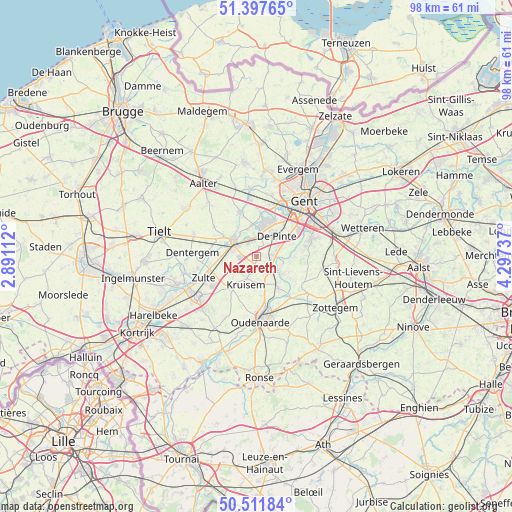
Nazareth GPS coordinates[2]
50° 57' 24.696" North, 3° 35' 39.3" East
| Map corner | latitude | longitude |
|---|---|---|
| Upper-left | 51.39765°, | 2.89112° |
| Center: | 50.95686°, | 3.59425° |
| Lower-right: | 50.51184°, | 4.29737° |
| Map W x H: | 98.5×98.5 km | = 61.2×61.2mi |
| max Lat: | 51.46791° ⇑33.6% North |
| Nazareth: | 50.95686° |
| min Lat: | ⇓66.4% South 49.53771° |
| min Long | Nazareth | max Long |
| 2.59368° | 3.59425° | 6.25749° |
| W 15%⇐ | ⇒85% E |
Elevation
Elevation of Nazareth is 12 m = 39 ft, and this is 87.5 m = 287 ft below average elevation for this country.
| Max E: |
582 m = 1909 ft | 82.3% |
| Avg. | 99.5 m = 326 ft | |
| Nazareth | 12 m = 39 ft | |
Min E: |
1 m = 3 ft | 17.7% |
See also: Belgium elevation on elevation.city.
Geographical zone
Nazareth is located in North temperate zone (between Tropic of Cancer and the Arctic Circle). Distance of this North polar circle is 1735.3 km =1078.3 mi to North.| Distance of | km | miles | from Nazareth |
|---|---|---|---|
| North Pole | 4341.2 | 2697.5 | to North |
| Arctic Circle | 1735.3 | 1078.3 | to North |
| Tropic Cancer | 3060 | 1901.4 | to South |
| Equator | 5665.9 | 3520.6 | to South |


Nearby cities:
15 places around Nazareth: (largest is in red/bold)
• De Pinte
5.5 km =3.4 mi,  42°
42°
• Deinze
5.2 km =3.2 mi,  301°
301°
• Dentergem
12.5 km =7.8 mi,  273°
273°
• Gavere
5.6 km =3.5 mi,  123°
123°
• Gent
13.4 km =8.3 mi, 39°
• Kruishoutem
7.8 km =4.8 mi,  217°
217°
• Ledeberg
13.9 km =8.6 mi,  49°
49°
• Merelbeke
11.4 km =7.1 mi,  68°
68°
• Nevele
9.4 km =5.8 mi,  338°
338°
• Oosterzele
14.3 km =8.9 mi,  91°
91°
• Oudenaarde
11.7 km =7.3 mi,  174°
174°
• Sint-Martens-Latem
7.1 km =4.4 mi,  25°
25°
• Waregem
13.9 km =8.6 mi,  237°
237°
• Zingem
7.2 km =4.5 mi,  144°
144°
• Zulte
11 km =6.8 mi,  247°
247°
Sources, notices
• [Note1] Compared only with cities in Belgium existing in our database
• [Src1] Map data: © OpenStreetMap contributors (CC-BY-SA)
• [Src2] Other city data from geonames.org with taken over terms of usage.
• [Src3] Geographical zone / Annual Mean Temperature by Robert A. Rohde @ Wikipedia
