De Pinte geodata
De Pinte (Flanders) is a populated place; located in Belgium in Europe/Brussels (GMT+2) time zone. With population of 10,020 people, there are 303 cities with bigger population in this country. Compared to other cities in Belgium, 70% of cities are located further ↓South; 83.4% of cities are located further →East and 93.3% of cities have higher elevation than De Pinte. Note1
Administrative division(s):
- Level 1: Flanders
- Level 2: Provincie Oost-Vlaanderen
- Level 3: Arrondissement Gent
- Level 4: De Pinte


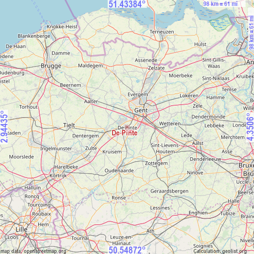
De Pinte GPS coordinates[2]
50° 59' 36.204" North, 3° 38' 50.892" East
| Map corner | latitude | longitude |
|---|---|---|
| Upper-left | 51.43384°, | 2.94435° |
| Center: | 50.99339°, | 3.64747° |
| Lower-right: | 50.54872°, | 4.3506° |
| Map W x H: | 98.4×98.4 km | = 61.1×61.1mi |
| max Lat: | 51.46791° ⇑30% North |
| De Pinte: | 50.99339° |
| min Lat: | ⇓70% South 49.53771° |
| min Long | De Pinte | max Long |
| 2.59368° | 3.64747° | 6.25749° |
| W 16.6%⇐ | ⇒83.4% E |
Elevation
Elevation of De Pinte is 7 m = 23 ft, and this is 92.5 m = 303 ft below average elevation for this country.
| Max E: |
582 m = 1909 ft | 93.3% |
| Avg. | 99.5 m = 326 ft | |
| De Pinte | 7 m = 23 ft | |
Min E: |
1 m = 3 ft | 6.7% |
See also: Belgium elevation on elevation.city.
Geographical zone
De Pinte is located in North temperate zone (between Tropic of Cancer and the Arctic Circle). Distance of this North polar circle is 1731.2 km =1075.7 mi to North.| Distance of | km | miles | from De Pinte |
|---|---|---|---|
| North Pole | 4337.1 | 2694.9 | to North |
| Arctic Circle | 1731.2 | 1075.7 | to North |
| Tropic Cancer | 3064 | 1903.9 | to South |
| Equator | 5669.9 | 3523.1 | to South |


Nearby cities:
15 places around De Pinte: (largest is in red/bold)
• Deinze
8.3 km =5.2 mi,  260°
260°
• Destelbergen
12.9 km =8 mi,  55°
55°
• Evergem
14 km =8.7 mi,  18°
18°
• Gavere
7.2 km =4.5 mi,  171°
171°
• Gent
7.9 km =4.9 mi,  37°
37°
• Kruishoutem
13.3 km =8.3 mi,  219°
219°
• Ledeberg
8.4 km =5.2 mi,  53°
53°
• Lovendegem
12.3 km =7.6 mi,  348°
348°
• Melle
11.1 km =6.9 mi,  84°
84°
• Merelbeke
6.9 km =4.3 mi,  89°
89°
• Nazareth
5.5 km =3.4 mi, 222°
• Nevele
8.5 km =5.3 mi,  303°
303°
• Oosterzele
11.5 km =7.1 mi,  113°
113°
• Sint-Martens-Latem
2.5 km =1.6 mi,  343°
343°
• Zingem
9.9 km =6.2 mi,  177°
177°
Sources, notices
• [Note1] Compared only with cities in Belgium existing in our database
• [Src1] Map data: © OpenStreetMap contributors (CC-BY-SA)
• [Src2] Other city data from geonames.org with taken over terms of usage.
• [Src3] Geographical zone / Annual Mean Temperature by Robert A. Rohde @ Wikipedia
