Diegem geodata
Diegem (Flanders) is a populated place; located in Belgium in Europe/Brussels (GMT+2) time zone. With population of 5,001 people, there are 455 cities with bigger population in this country. Compared to other cities in Belgium, 59.9% of cities are located further ↓South; 58.5% of cities are located further →East and 73.1% of cities have higher elevation than Diegem. Note1
Administrative division(s):
- Level 1: Flanders
- Level 2: Provincie Vlaams-Brabant
- Level 3: Arrondissement Halle-Vilvoorde
- Level 4: Machelen


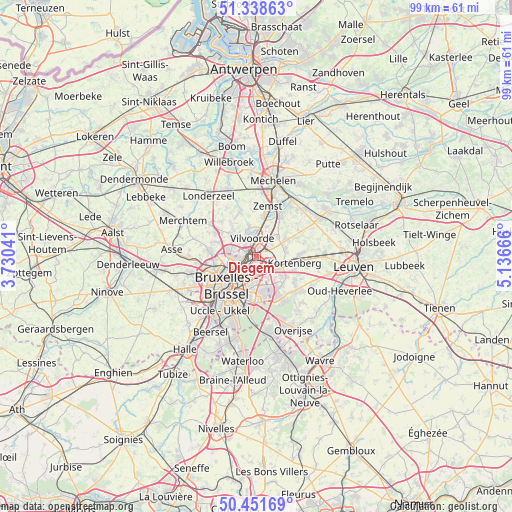
Diegem GPS coordinates[2]
50° 53' 50.172" North, 4° 26' 0.744" East
| Map corner | latitude | longitude |
|---|---|---|
| Upper-left | 51.33863°, | 3.73041° |
| Center: | 50.89727°, | 4.43354° |
| Lower-right: | 50.45169°, | 5.13666° |
| Map W x H: | 98.6×98.6 km | = 61.3×61.3mi |
| max Lat: | 51.46791° ⇑40.1% North |
| Diegem: | 50.89727° |
| min Lat: | ⇓59.9% South 49.53771° |
| min Long | Diegem | max Long |
| 2.59368° | 4.43354° | 6.25749° |
| W 41.5%⇐ | ⇒58.5% E |
Elevation
Elevation of Diegem is 19 m = 62 ft, and this is 80.5 m = 264 ft below average elevation for this country.
| Max E: |
582 m = 1909 ft | 73.1% |
| Avg. | 99.5 m = 326 ft | |
| Diegem | 19 m = 62 ft | |
Min E: |
1 m = 3 ft | 26.9% |
See also: Belgium elevation on elevation.city.
Geographical zone
Diegem is located in North temperate zone (between Tropic of Cancer and the Arctic Circle). Distance of this North polar circle is 1741.9 km =1082.4 mi to North.| Distance of | km | miles | from Diegem |
|---|---|---|---|
| North Pole | 4347.8 | 2701.6 | to North |
| Arctic Circle | 1741.9 | 1082.4 | to North |
| Tropic Cancer | 3053.3 | 1897.2 | to South |
| Equator | 5659.2 | 3516.5 | to South |


Nearby cities:
15 places around Diegem: (largest is in red/bold)
• Bever
8.5 km =5.3 mi,  284°
284°
• Brussels
7.9 km =4.9 mi,  228°
228°
• Grimbergen
5.9 km =3.7 mi,  313°
313°
• Kampenhout
9.6 km =6 mi,  58°
58°
• Kortenberg
7.8 km =4.8 mi,  96°
96°
• Kraainem
4.7 km =2.9 mi,  147°
147°
• Machelen
1.6 km =1 mi,  21°
21°
• Meise
8.8 km =5.5 mi,  301°
301°
• Steenokkerzeel
5.9 km =3.7 mi,  66°
66°
• Tervuren
9.9 km =6.2 mi, 145°
• Vilvoorde
3.4 km =2.1 mi,  355°
355°
• Wemmel
9 km =5.6 mi, 277°
• Wezembeek-Oppem
7.7 km =4.8 mi, 146°
• Zaventem
3.2 km =2 mi,  118°
118°
• Zemst
9.7 km =6 mi,  11°
11°
Sources, notices
• [Note1] Compared only with cities in Belgium existing in our database
• [Src1] Map data: © OpenStreetMap contributors (CC-BY-SA)
• [Src2] Other city data from geonames.org with taken over terms of usage.
• [Src3] Geographical zone / Annual Mean Temperature by Robert A. Rohde @ Wikipedia
