Wemmel geodata
Wemmel (Flanders) is a populated place; located in Belgium in Europe/Brussels (GMT+2) time zone. With population of 14,406 people, there are 195 cities with bigger population in this country. Compared to other cities in Belgium, 61.2% of cities are located further ↓South; 64.1% of cities are located further →East and 57.2% of cities have higher elevation than Wemmel. Note1
Administrative division(s):
- Level 1: Flanders
- Level 2: Provincie Vlaams-Brabant
- Level 3: Arrondissement Halle-Vilvoorde
- Level 4: Wemmel


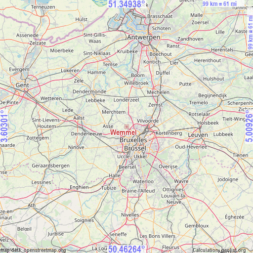
Wemmel GPS coordinates[2]
50° 54' 29.232" North, 4° 18' 22.068" East
| Map corner | latitude | longitude |
|---|---|---|
| Upper-left | 51.34938°, | 3.60301° |
| Center: | 50.90812°, | 4.30613° |
| Lower-right: | 50.46264°, | 5.00926° |
| Map W x H: | 98.6×98.6 km | = 61.3×61.3mi |
| max Lat: | 51.46791° ⇑38.8% North |
| Wemmel: | 50.90812° |
| min Lat: | ⇓61.2% South 49.53771° |
| min Long | Wemmel | max Long |
| 2.59368° | 4.30613° | 6.25749° |
| W 35.9%⇐ | ⇒64.1% E |
Elevation
Elevation of Wemmel is 39 m = 128 ft, and this is 60.5 m = 198 ft below average elevation for this country.
| Max E: |
582 m = 1909 ft | 57.2% |
| Avg. | 99.5 m = 326 ft | |
| Wemmel | 39 m = 128 ft | |
Min E: |
1 m = 3 ft | 42.8% |
See also: Belgium elevation on elevation.city.
Geographical zone
Wemmel is located in North temperate zone (between Tropic of Cancer and the Arctic Circle). Distance of this North polar circle is 1740.7 km =1081.6 mi to North.| Distance of | km | miles | from Wemmel |
|---|---|---|---|
| North Pole | 4346.6 | 2700.9 | to North |
| Arctic Circle | 1740.7 | 1081.6 | to North |
| Tropic Cancer | 3054.5 | 1898 | to South |
| Equator | 5660.5 | 3517.3 | to South |


Nearby cities:
15 places around Wemmel: (largest is in red/bold)
• Asse
7.6 km =4.7 mi,  271°
271°
• Bever
1.2 km =0.7 mi,  37°
37°
• Brussels
7.1 km =4.4 mi,  154°
154°
• Diegem
9 km =5.6 mi,  97°
97°
• Dilbeek
7.4 km =4.6 mi,  205°
205°
• Grimbergen
5.5 km =3.4 mi,  58°
58°
• Kapelle-op-den-Bos
12 km =7.5 mi,  19°
19°
• Londerzeel
10.7 km =6.6 mi,  358°
358°
• Machelen
9.5 km =5.9 mi,  88°
88°
• Meise
3.8 km =2.4 mi, 22°
• Merchtem
7.1 km =4.4 mi,  312°
312°
• Opwijk
10.8 km =6.7 mi, 307°
• Ternat
10.8 km =6.7 mi,  244°
244°
• Vilvoorde
8.9 km =5.5 mi,  75°
75°
• Zaventem
12 km =7.5 mi, 103°
Sources, notices
• [Note1] Compared only with cities in Belgium existing in our database
• [Src1] Map data: © OpenStreetMap contributors (CC-BY-SA)
• [Src2] Other city data from geonames.org with taken over terms of usage.
• [Src3] Geographical zone / Annual Mean Temperature by Robert A. Rohde @ Wikipedia
