Kampenhout geodata
Kampenhout (Flanders) is a populated place; located in Belgium in Europe/Brussels (GMT+2) time zone. With population of 10,784 people, there are 283 cities with bigger population in this country. Compared to other cities in Belgium, 65.2% of cities are located further ↓South; 50.7% of cities are located further →East and 79.4% of cities have higher elevation than Kampenhout. Note1
Administrative division(s):
- Level 1: Flanders
- Level 2: Provincie Vlaams-Brabant
- Level 3: Arrondissement Halle-Vilvoorde
- Level 4: Kampenhout


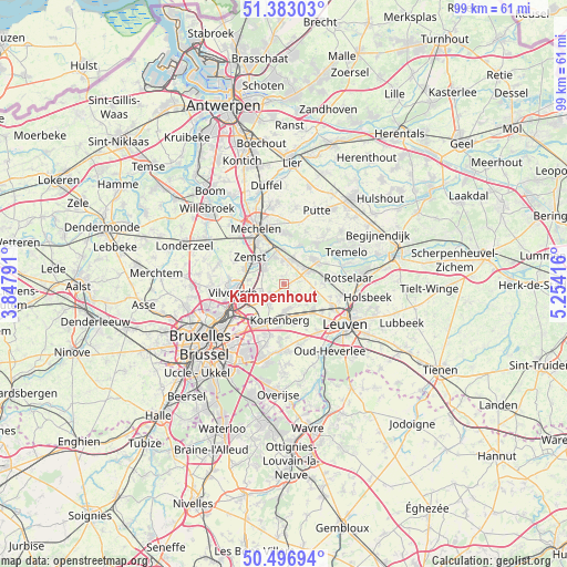
Kampenhout GPS coordinates[2]
50° 56' 31.56" North, 4° 33' 3.708" East
| Map corner | latitude | longitude |
|---|---|---|
| Upper-left | 51.38303°, | 3.84791° |
| Center: | 50.9421°, | 4.55103° |
| Lower-right: | 50.49694°, | 5.25416° |
| Map W x H: | 98.5×98.5 km | = 61.2×61.2mi |
| max Lat: | 51.46791° ⇑34.8% North |
| Kampenhout: | 50.9421° |
| min Lat: | ⇓65.2% South 49.53771° |
| min Long | Kampenhout | max Long |
| 2.59368° | 4.55103° | 6.25749° |
| W 49.3%⇐ | ⇒50.7% E |
Elevation
Elevation of Kampenhout is 14 m = 46 ft, and this is 85.5 m = 281 ft below average elevation for this country.
| Max E: |
582 m = 1909 ft | 79.4% |
| Avg. | 99.5 m = 326 ft | |
| Kampenhout | 14 m = 46 ft | |
Min E: |
1 m = 3 ft | 20.6% |
See also: Belgium elevation on elevation.city.
Geographical zone
Kampenhout is located in North temperate zone (between Tropic of Cancer and the Arctic Circle). Distance of this North polar circle is 1736.9 km =1079.3 mi to North.| Distance of | km | miles | from Kampenhout |
|---|---|---|---|
| North Pole | 4342.8 | 2698.5 | to North |
| Arctic Circle | 1736.9 | 1079.3 | to North |
| Tropic Cancer | 3058.3 | 1900.3 | to South |
| Equator | 5664.2 | 3519.6 | to South |


Nearby cities:
15 places around Kampenhout: (largest is in red/bold)
• Bertem
10.3 km =6.4 mi,  147°
147°
• Bonheiden
9 km =5.6 mi,  358°
358°
• Boortmeerbeek
4.4 km =2.7 mi,  21°
21°
• Diegem
9.6 km =6 mi,  238°
238°
• Haacht
7.2 km =4.5 mi,  57°
57°
• Herent
9.2 km =5.7 mi,  113°
113°
• Keerbergen
8.9 km =5.5 mi,  40°
40°
• Kortenberg
5.8 km =3.6 mi,  185°
185°
• Kraainem
10.6 km =6.6 mi,  212°
212°
• Machelen
8.4 km =5.2 mi,  245°
245°
• Mechelen
10.6 km =6.6 mi,  331°
331°
• Steenokkerzeel
3.9 km =2.4 mi,  227°
227°
• Vilvoorde
8.7 km =5.4 mi,  259°
259°
• Zaventem
8.5 km =5.3 mi,  220°
220°
• Zemst
7.8 km =4.8 mi,  305°
305°
Sources, notices
• [Note1] Compared only with cities in Belgium existing in our database
• [Src1] Map data: © OpenStreetMap contributors (CC-BY-SA)
• [Src2] Other city data from geonames.org with taken over terms of usage.
• [Src3] Geographical zone / Annual Mean Temperature by Robert A. Rohde @ Wikipedia
