Zemst geodata
Zemst (Flanders) is a populated place; located in Belgium in Europe/Brussels (GMT+2) time zone. With population of 21,096 people, there are 109 cities with bigger population in this country. Compared to other cities in Belgium, 68.6% of cities are located further ↓South; 56.9% of cities are located further →East and 83.8% of cities have higher elevation than Zemst. Note1
Administrative division(s):
- Level 1: Flanders
- Level 2: Provincie Vlaams-Brabant
- Level 3: Arrondissement Halle-Vilvoorde
- Level 4: Zemst


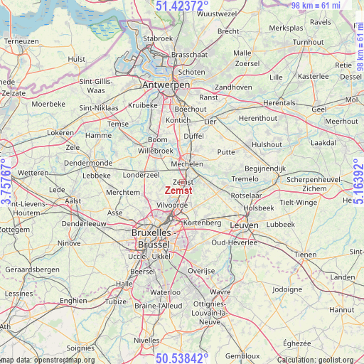
Zemst GPS coordinates[2]
50° 58' 59.448" North, 4° 27' 38.844" East
| Map corner | latitude | longitude |
|---|---|---|
| Upper-left | 51.42372°, | 3.75767° |
| Center: | 50.98318°, | 4.46079° |
| Lower-right: | 50.53842°, | 5.16392° |
| Map W x H: | 98.4×98.4 km | = 61.1×61.1mi |
| max Lat: | 51.46791° ⇑31.4% North |
| Zemst: | 50.98318° |
| min Lat: | ⇓68.6% South 49.53771° |
| min Long | Zemst | max Long |
| 2.59368° | 4.46079° | 6.25749° |
| W 43.1%⇐ | ⇒56.9% E |
Elevation
Elevation of Zemst is 11 m = 36 ft, and this is 88.5 m = 290 ft below average elevation for this country.
| Max E: |
582 m = 1909 ft | 83.8% |
| Avg. | 99.5 m = 326 ft | |
| Zemst | 11 m = 36 ft | |
Min E: |
1 m = 3 ft | 16.2% |
See also: Belgium elevation on elevation.city.
Geographical zone
Zemst is located in North temperate zone (between Tropic of Cancer and the Arctic Circle). Distance of this North polar circle is 1732.4 km =1076.5 mi to North.| Distance of | km | miles | from Zemst |
|---|---|---|---|
| North Pole | 4338.3 | 2695.7 | to North |
| Arctic Circle | 1732.4 | 1076.5 | to North |
| Tropic Cancer | 3062.9 | 1903.2 | to South |
| Equator | 5668.8 | 3522.4 | to South |


Nearby cities:
15 places around Zemst: (largest is in red/bold)
• Bonheiden
7.5 km =4.7 mi,  54°
54°
• Boortmeerbeek
8 km =5 mi,  93°
93°
• Diegem
9.7 km =6 mi,  191°
191°
• Grimbergen
8.3 km =5.2 mi,  228°
228°
• Kampenhout
7.8 km =4.8 mi,  125°
125°
• Kapelle-op-den-Bos
7.4 km =4.6 mi,  293°
293°
• Londerzeel
11.3 km =7 mi,  282°
282°
• Machelen
8.2 km =5.1 mi, 189°
• Mechelen
4.9 km =3 mi,  13°
13°
• Meise
10.6 km =6.6 mi,  242°
242°
• Sint-Katelijne-Waver
10.6 km =6.6 mi,  29°
29°
• Steenokkerzeel
8 km =5 mi,  154°
154°
• Vilvoorde
6.5 km =4 mi,  199°
199°
• Willebroek
11.1 km =6.9 mi,  320°
320°
• Zaventem
11.1 km =6.9 mi,  175°
175°
Sources, notices
• [Note1] Compared only with cities in Belgium existing in our database
• [Src1] Map data: © OpenStreetMap contributors (CC-BY-SA)
• [Src2] Other city data from geonames.org with taken over terms of usage.
• [Src3] Geographical zone / Annual Mean Temperature by Robert A. Rohde @ Wikipedia
