Brasschaat geodata
Brasschaat (Flanders) is a populated place; located in Belgium in Europe/Brussels (GMT+2) time zone. With population of 37,040 people, there are 32 cities with bigger population in this country. Compared to other cities in Belgium, 96.2% of cities are located further ↓South; 54.9% of cities are located further →East and 86.5% of cities have higher elevation than Brasschaat. Note1
Administrative division(s):
- Level 1: Flanders
- Level 2: Provincie Antwerpen
- Level 3: Arrondissement Antwerpen
- Level 4: Brasschaat


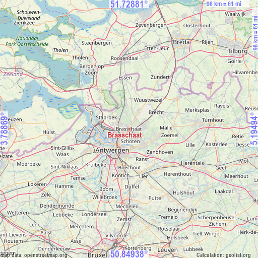
Brasschaat GPS coordinates[2]
51° 17' 28.32" North, 4° 29' 30.552" East
| Map corner | latitude | longitude |
|---|---|---|
| Upper-left | 51.72881°, | 3.78869° |
| Center: | 51.2912°, | 4.49182° |
| Lower-right: | 50.84938°, | 5.19494° |
| Map W x H: | 97.8×97.8 km | = 60.8×60.8mi |
| max Lat: | 51.46791° ⇑3.8% North |
| Brasschaat: | 51.2912° |
| min Lat: | ⇓96.2% South 49.53771° |
| min Long | Brasschaat | max Long |
| 2.59368° | 4.49182° | 6.25749° |
| W 45.1%⇐ | ⇒54.9% E |
Elevation
Elevation of Brasschaat is 10 m = 33 ft, and this is 89.5 m = 294 ft below average elevation for this country.
| Max E: |
582 m = 1909 ft | 86.5% |
| Avg. | 99.5 m = 326 ft | |
| Brasschaat | 10 m = 33 ft | |
Min E: |
1 m = 3 ft | 13.5% |
See also: Belgium elevation on elevation.city.
Geographical zone
Brasschaat is located in North temperate zone (between Tropic of Cancer and the Arctic Circle). Distance of this North polar circle is 1698.1 km =1055.2 mi to North.| Distance of | km | miles | from Brasschaat |
|---|---|---|---|
| North Pole | 4304 | 2674.4 | to North |
| Arctic Circle | 1698.1 | 1055.2 | to North |
| Tropic Cancer | 3097.1 | 1924.4 | to South |
| Equator | 5703 | 3543.7 | to South |


Nearby cities:
15 places around Brasschaat: (largest is in red/bold)
• Antwerpen
10 km =6.2 mi,  217°
217°
• Borsbeek
10.5 km =6.5 mi,  182°
182°
• Brecht
12.1 km =7.5 mi,  57°
57°
• Deurne
8 km =5 mi,  193°
193°
• Kalmthout
10.4 km =6.5 mi,  353°
353°
• Kapellen
4.7 km =2.9 mi,  302°
302°
• Mortsel
14.1 km =8.8 mi, 191°
• Ranst
12.4 km =7.7 mi,  155°
155°
• Schilde
8.5 km =5.3 mi,  131°
131°
• Schoten
4.4 km =2.7 mi,  170°
170°
• Stabroek
9.5 km =5.9 mi, 298°
• Wijnegem
7.3 km =4.5 mi, 164°
• Wommelgem
9.9 km =6.2 mi, 167°
• Wuustwezel
13.3 km =8.3 mi,  32°
32°
• Zwijndrecht
14 km =8.7 mi,  235°
235°
Sources, notices
• [Note1] Compared only with cities in Belgium existing in our database
• [Src1] Map data: © OpenStreetMap contributors (CC-BY-SA)
• [Src2] Other city data from geonames.org with taken over terms of usage.
• [Src3] Geographical zone / Annual Mean Temperature by Robert A. Rohde @ Wikipedia
