Wuustwezel geodata
Wuustwezel (Flanders) is a populated place; located in Belgium in Europe/Brussels (GMT+2) time zone. With population of 18,117 people, there are 140 cities with bigger population in this country. Compared to other cities in Belgium, 99.5% of cities are located further ↓South; 50.9% of cities are located further ←West and 74.9% of cities have higher elevation than Wuustwezel. Note1
Administrative division(s):
- Level 1: Flanders
- Level 2: Provincie Antwerpen
- Level 3: Arrondissement Antwerpen
- Level 4: Wuustwezel


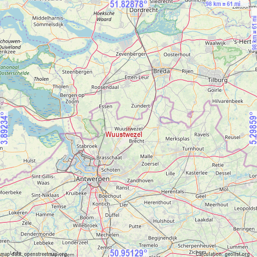
Wuustwezel GPS coordinates[2]
51° 23' 31.704" North, 4° 35' 43.656" East
| Map corner | latitude | longitude |
|---|---|---|
| Upper-left | 51.82878°, | 3.89234° |
| Center: | 51.39214°, | 4.59546° |
| Lower-right: | 50.95129°, | 5.29859° |
| Map W x H: | 97.6×97.6 km | = 60.6×60.6mi |
| max Lat: | 51.46791° ⇑0.5% North |
| Wuustwezel: | 51.39214° |
| min Lat: | ⇓99.5% South 49.53771° |
| min Long | Wuustwezel | max Long |
| 2.59368° | 4.59546° | 6.25749° |
| W 50.9%⇐ | ⇒49.1% E |
Elevation
Elevation of Wuustwezel is 18 m = 59 ft, and this is 81.5 m = 267 ft below average elevation for this country.
| Max E: |
582 m = 1909 ft | 74.9% |
| Avg. | 99.5 m = 326 ft | |
| Wuustwezel | 18 m = 59 ft | |
Min E: |
1 m = 3 ft | 25.1% |
See also: Belgium elevation on elevation.city.
Geographical zone
Wuustwezel is located in North temperate zone (between Tropic of Cancer and the Arctic Circle). Distance of this North polar circle is 1686.9 km =1048.2 mi to North.| Distance of | km | miles | from Wuustwezel |
|---|---|---|---|
| North Pole | 4292.8 | 2667.4 | to North |
| Arctic Circle | 1686.9 | 1048.2 | to North |
| Tropic Cancer | 3108.4 | 1931.5 | to South |
| Equator | 5714.3 | 3550.7 | to South |


Nearby cities:
15 places around Wuustwezel: (largest is in red/bold)
• Beerse
19.6 km =12.2 mi,  114°
114°
• Brasschaat
13.3 km =8.3 mi,  212°
212°
• Brecht
5.5 km =3.4 mi,  147°
147°
• Essen
12.2 km =7.6 mi,  313°
313°
• Hoogstraten
11.5 km =7.1 mi,  85°
85°
• Kalmthout
8.4 km =5.2 mi,  264°
264°
• Kapellen
14.1 km =8.8 mi,  231°
231°
• Merksplas
19.1 km =11.9 mi,  101°
101°
• Oostmalle
14 km =8.7 mi,  136°
136°
• Rijkevorsel
12.5 km =7.8 mi, 113°
• Schilde
16.8 km =10.4 mi,  182°
182°
• Schoten
16.8 km =10.4 mi,  202°
202°
• Stabroek
16.9 km =10.5 mi,  246°
246°
• Wijnegem
19 km =11.8 mi, 196°
• Zoersel
16 km =9.9 mi, 149°
Sources, notices
• [Note1] Compared only with cities in Belgium existing in our database
• [Src1] Map data: © OpenStreetMap contributors (CC-BY-SA)
• [Src2] Other city data from geonames.org with taken over terms of usage.
• [Src3] Geographical zone / Annual Mean Temperature by Robert A. Rohde @ Wikipedia
