Brecht geodata
Brecht (Flanders) is a populated place; located in Belgium in Europe/Brussels (GMT+2) time zone. With population of 25,908 people, there are 78 cities with bigger population in this country. Compared to other cities in Belgium, 98.7% of cities are located further ↓South; 53.1% of cities are located further ←West and 68.2% of cities have higher elevation than Brecht. Note1
Administrative division(s):
- Level 1: Flanders
- Level 2: Provincie Antwerpen
- Level 3: Arrondissement Antwerpen
- Level 4: Brecht


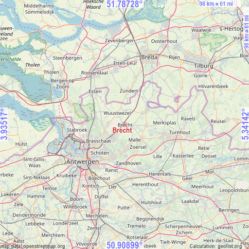
Brecht GPS coordinates[2]
51° 21' 0.864" North, 4° 38' 17.844" East
| Map corner | latitude | longitude |
|---|---|---|
| Upper-left | 51.78728°, | 3.93517° |
| Center: | 51.35024°, | 4.63829° |
| Lower-right: | 50.90899°, | 5.34142° |
| Map W x H: | 97.7×97.7 km | = 60.7×60.7mi |
| max Lat: | 51.46791° ⇑1.3% North |
| Brecht: | 51.35024° |
| min Lat: | ⇓98.7% South 49.53771° |
| min Long | Brecht | max Long |
| 2.59368° | 4.63829° | 6.25749° |
| W 53.1%⇐ | ⇒46.9% E |
Elevation
Elevation of Brecht is 23 m = 75 ft, and this is 76.5 m = 251 ft below average elevation for this country.
| Max E: |
582 m = 1909 ft | 68.2% |
| Avg. | 99.5 m = 326 ft | |
| Brecht | 23 m = 75 ft | |
Min E: |
1 m = 3 ft | 31.8% |
See also: Belgium elevation on elevation.city.
Geographical zone
Brecht is located in North temperate zone (between Tropic of Cancer and the Arctic Circle). Distance of this North polar circle is 1691.6 km =1051.1 mi to North.| Distance of | km | miles | from Brecht |
|---|---|---|---|
| North Pole | 4297.5 | 2670.3 | to North |
| Arctic Circle | 1691.6 | 1051.1 | to North |
| Tropic Cancer | 3103.7 | 1928.5 | to South |
| Equator | 5709.6 | 3547.8 | to South |


Nearby cities:
15 places around Brecht: (largest is in red/bold)
• Beerse
15.3 km =9.5 mi,  102°
102°
• Brasschaat
12.1 km =7.5 mi,  237°
237°
• Hoogstraten
10.1 km =6.3 mi,  56°
56°
• Kalmthout
11.9 km =7.4 mi,  288°
288°
• Kapellen
14.7 km =9.1 mi,  253°
253°
• Lille
17.6 km =10.9 mi,  133°
133°
• Merksplas
15.8 km =9.8 mi,  86°
86°
• Oostmalle
8.6 km =5.3 mi, 130°
• Rijkevorsel
8.5 km =5.3 mi, 91°
• Schilde
12.7 km =7.9 mi,  197°
197°
• Schoten
14.4 km =8.9 mi,  220°
220°
• Wijnegem
15.9 km =9.9 mi,  211°
211°
• Wuustwezel
5.5 km =3.4 mi,  327°
327°
• Zandhoven
15.1 km =9.4 mi,  173°
173°
• Zoersel
10.5 km =6.5 mi,  150°
150°
Sources, notices
• [Note1] Compared only with cities in Belgium existing in our database
• [Src1] Map data: © OpenStreetMap contributors (CC-BY-SA)
• [Src2] Other city data from geonames.org with taken over terms of usage.
• [Src3] Geographical zone / Annual Mean Temperature by Robert A. Rohde @ Wikipedia
