Aalter geodata
Aalter (Flanders) is a populated place; located in Belgium in Europe/Brussels (GMT+2) time zone. With population of 18,802 people, there are 133 cities with bigger population in this country. Compared to other cities in Belgium, 78.9% of cities are located further ↓South; 87.4% of cities are located further →East and 76.2% of cities have higher elevation than Aalter. Note1
Administrative division(s):
- Level 1: Flanders
- Level 2: Provincie Oost-Vlaanderen
- Level 3: Arrondissement Gent
- Level 4: Aalter


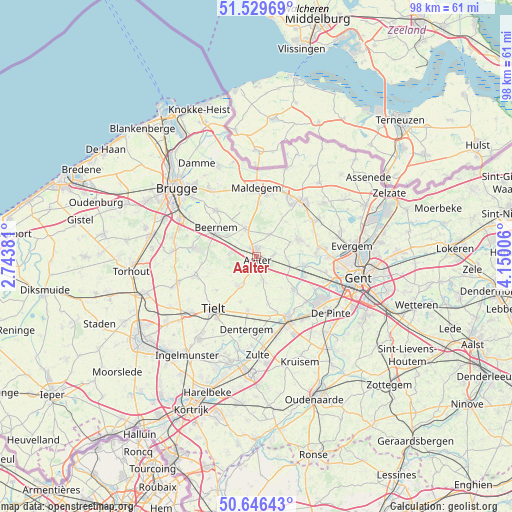
Aalter GPS coordinates[2]
51° 5' 24.612" North, 3° 26' 48.948" East
| Map corner | latitude | longitude |
|---|---|---|
| Upper-left | 51.52969°, | 2.74381° |
| Center: | 51.09017°, | 3.44693° |
| Lower-right: | 50.64643°, | 4.15006° |
| Map W x H: | 98.2×98.2 km | = 61×61mi |
| max Lat: | 51.46791° ⇑21.1% North |
| Aalter: | 51.09017° |
| min Lat: | ⇓78.9% South 49.53771° |
| min Long | Aalter | max Long |
| 2.59368° | 3.44693° | 6.25749° |
| W 12.6%⇐ | ⇒87.4% E |
Elevation
Elevation of Aalter is 17 m = 56 ft, and this is 82.5 m = 271 ft below average elevation for this country.
| Max E: |
582 m = 1909 ft | 76.2% |
| Avg. | 99.5 m = 326 ft | |
| Aalter | 17 m = 56 ft | |
Min E: |
1 m = 3 ft | 23.8% |
See also: Belgium elevation on elevation.city.
Geographical zone
Aalter is located in North temperate zone (between Tropic of Cancer and the Arctic Circle). Distance of this North polar circle is 1720.5 km =1069.1 mi to North.| Distance of | km | miles | from Aalter |
|---|---|---|---|
| North Pole | 4326.4 | 2688.3 | to North |
| Arctic Circle | 1720.5 | 1069.1 | to North |
| Tropic Cancer | 3074.8 | 1910.6 | to South |
| Equator | 5680.7 | 3529.8 | to South |


Nearby cities:
15 places around Aalter: (largest is in red/bold)
• Beernem
9.3 km =5.8 mi,  306°
306°
• Deinze
13.4 km =8.3 mi,  154°
154°
• Dentergem
14.2 km =8.8 mi,  188°
188°
• Eeklo
13.2 km =8.2 mi,  35°
35°
• Knesselare
6 km =3.7 mi,  336°
336°
• Lovendegem
11.7 km =7.3 mi,  83°
83°
• Maldegem
13 km =8.1 mi,  359°
359°
• Nevele
9.2 km =5.7 mi,  131°
131°
• Oostkamp
16.7 km =10.4 mi,  295°
295°
• Ruiselede
6.7 km =4.2 mi,  213°
213°
• Sint-Martens-Latem
15.8 km =9.8 mi,  122°
122°
• Tielt
13.1 km =8.1 mi,  219°
219°
• Waarschoot
13 km =8.1 mi,  57°
57°
• Wingene
12.6 km =7.8 mi,  253°
253°
• Zomergem
8.9 km =5.5 mi,  68°
68°
Sources, notices
• [Note1] Compared only with cities in Belgium existing in our database
• [Src1] Map data: © OpenStreetMap contributors (CC-BY-SA)
• [Src2] Other city data from geonames.org with taken over terms of usage.
• [Src3] Geographical zone / Annual Mean Temperature by Robert A. Rohde @ Wikipedia
