Lovech geodata
Lovech is a seat of a first-order administrative division; located in Bulgaria in Europe/Sofia (GMT+3) time zone. With population of 42,211 people, there are 25 cities with bigger population in this country. Compared to other cities in Bulgaria, 61.7% of cities are located further ↓South; 57% of cities are located further →East and 62.3% of cities have higher elevation than Lovech. Note1


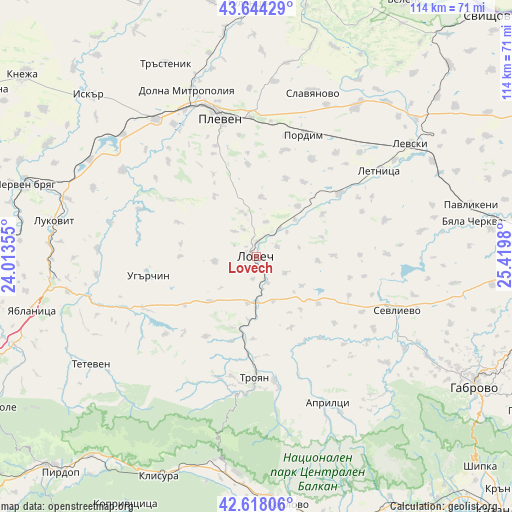
Lovech GPS coordinates[2]
43° 7' 59.988" North, 24° 43' 0.012" East
| Map corner | latitude | longitude |
|---|---|---|
| Upper-left | 43.64429°, | 24.01355° |
| Center: | 43.13333°, | 24.71667° |
| Lower-right: | 42.61806°, | 25.4198° |
| Map W x H: | 114.1×114.1 km | = 70.9×70.9mi |
| max Lat: | 44.16214° ⇑38.3% North |
| Lovech: | 43.13333° |
| min Lat: | ⇓61.7% South 41.32715° |
| min Long | Lovech | max Long |
| 22.52139° | 24.71667° | 28.53429° |
| W 43%⇐ | ⇒57% E |
Elevation
Elevation of Lovech is 179 m = 587 ft, and this is 137.6 m = 451 ft below average elevation for this country.
| Max E: |
1221 m = 4006 ft | 62.3% |
| Avg. | 316.6 m = 1039 ft | |
| Lovech | 179 m = 587 ft | |
Min E: |
1 m = 3 ft | 37.7% |
See also: Lovech elevation on elevation.city.
Geographical zone
Lovech is located in North temperate zone (between Tropic of Cancer and the Arctic Circle). Distance of this Northern Tropic circle is 2190.1 km =1360.9 mi to South.| Distance of | km | miles | from Lovech |
|---|---|---|---|
| North Pole | 5211.1 | 3238 | to North |
| Arctic Circle | 2605.2 | 1618.8 | to North |
| Tropic Cancer | 2190.1 | 1360.9 | to South |
| Equator | 4796 | 2980.1 | to South |


Nearby cities:
15 places around Lovech: (largest is in red/bold)
• Apriltsi
36.3 km =22.6 mi,  153°
153°
• Byala Cherkva
47.9 km =29.8 mi,  81°
81°
• Dolna Mitropolia
39.9 km =24.8 mi,  338°
338°
• Dolni Dabnik
37.5 km =23.3 mi,  322°
322°
• Letnitsa
35 km =21.7 mi,  55°
55°
• Levski
42.6 km =26.5 mi,  52°
52°
• Lukovit
45.2 km =28.1 mi,  279°
279°
• Pleven
32.5 km =20.2 mi,  345°
345°
• Pordim
29.8 km =18.5 mi,  21°
21°
• Sevlievo
34.4 km =21.4 mi,  110°
110°
• Slavyanovo
39 km =24.2 mi, 18°
• Suhindol
38.2 km =23.7 mi, 80°
• Teteven
43.8 km =27.2 mi,  236°
236°
• Troyan
26.6 km =16.5 mi,  180°
180°
• Ugarchin
24.6 km =15.3 mi,  261°
261°
Sources, notices
• [Note1] Compared only with cities in Bulgaria existing in our database
• [Src1] Map data: © OpenStreetMap contributors (CC-BY-SA)
• [Src2] Other city data from geonames.org with taken over terms of usage.
• [Src3] Geographical zone / Annual Mean Temperature by Robert A. Rohde @ Wikipedia
