Gabrovo geodata
Gabrovo is a seat of a first-order administrative division; located in Bulgaria in Europe/Sofia (GMT+3) time zone. With population of 66,175 people, there are 16 cities with bigger population in this country. Compared to other cities in Bulgaria, 51.7% of cities are located further ↓South; 55.3% of cities are located further ←West and 81% of cities have lower elevation than Gabrovo. Note1


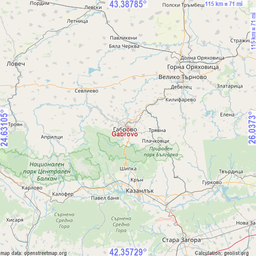
Gabrovo GPS coordinates[2]
42° 52' 28.992" North, 25° 20' 3.012" East
| Map corner | latitude | longitude |
|---|---|---|
| Upper-left | 43.38785°, | 24.63105° |
| Center: | 42.87472°, | 25.33417° |
| Lower-right: | 42.35729°, | 26.0373° |
| Map W x H: | 114.6×114.6 km | = 71.2×71.2mi |
| max Lat: | 44.16214° ⇑48.3% North |
| Gabrovo: | 42.87472° |
| min Lat: | ⇓51.7% South 41.32715° |
| min Long | Gabrovo | max Long |
| 22.52139° | 25.33417° | 28.53429° |
| W 55.3%⇐ | ⇒44.7% E |
Elevation
Elevation of Gabrovo is 538 m = 1765 ft, and this is 221.4 m = 726 ft above average elevation for this country.
| Max E: |
1221 m = 4006 ft | 19% |
| Gabrovo | 538 m 1765 ft | |
| Avg. | 316.6 m = 1039 ft | |
Min E: |
1 m = 3 ft | 81% |
See also: Gabrovo elevation on elevation.city.
Geographical zone
Gabrovo is located in North temperate zone (between Tropic of Cancer and the Arctic Circle). Distance of this Northern Tropic circle is 2161.3 km =1343 mi to South.| Distance of | km | miles | from Gabrovo |
|---|---|---|---|
| North Pole | 5239.8 | 3255.9 | to North |
| Arctic Circle | 2634 | 1636.7 | to North |
| Tropic Cancer | 2161.3 | 1343 | to South |
| Equator | 4767.2 | 2962.2 | to South |


Nearby cities:
15 places around Gabrovo: (largest is in red/bold)
• Apriltsi
34.2 km =21.3 mi,  263°
263°
• Asen
27.3 km =17 mi,  203°
203°
• Byala Cherkva
36.3 km =22.6 mi,  355°
355°
• Debelets
29 km =18 mi,  52°
52°
• Dryanovo
16.5 km =10.3 mi, 45°
• Kazanlak
29.2 km =18.1 mi,  169°
169°
• Kilifarevo
27.2 km =16.9 mi,  63°
63°
• Maglizh
35.3 km =21.9 mi,  150°
150°
• Parvomaytsi
40 km =24.9 mi,  39°
39°
• Pavel Banya
32.5 km =20.2 mi, 199°
• Sevlievo
24.6 km =15.3 mi,  313°
313°
• Shipka
17.6 km =10.9 mi,  180°
180°
• Suhindol
37.4 km =23.2 mi,  340°
340°
• Tryavna
13.5 km =8.4 mi,  93°
93°
• Veliko Tŭrnovo
33.2 km =20.6 mi, 46°
Sources, notices
• [Note1] Compared only with cities in Bulgaria existing in our database
• [Src1] Map data: © OpenStreetMap contributors (CC-BY-SA)
• [Src2] Other city data from geonames.org with taken over terms of usage.
• [Src3] Geographical zone / Annual Mean Temperature by Robert A. Rohde @ Wikipedia
